 Filter: Categories of Wisconsin Historical Images
Filter: Subject of Harbors
Filter: Year of 1800-1899
Filter: Subject of piers
Filter: Categories of Wisconsin Historical Images
Filter: Subject of Harbors
Filter: Year of 1800-1899
Filter: Subject of piers
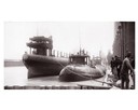
| Date: | 04 1893 |
|---|---|
| Description: | Captain Abe McDougall's whaleback boat, docked at the American Steel Barge Company. |

| Date: | 1886 |
|---|---|
| Description: | Bird's-eye view of Ashland, on the shores of Lake Superior, with insets of The Apostle Islands Chequamagon Bay & Ashland, and Distances from Ashland. |
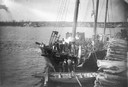
| Date: | 1888 |
|---|---|
| Description: | Elevated view of men repairing a docked, damaged ship. A shoreline is in the distance. |

| Date: | 1892 |
|---|---|
| Description: | Bird's-eye view of Chicago, with ships in the Lake Michigan harbor. |

| Date: | 1892 |
|---|---|
| Description: | Bird's-eye view of the Columbian Exposition pavilions from the vantage point of Lake Michigan. Included is an inset of the Union Passenger Station (now Uni... |
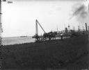
| Date: | 1899 |
|---|---|
| Description: | A man in work clothes is operating a horse-drawn mower in a patch of grass along a waterfront, while another man wearing a hat and tie is looking on. Ships... |
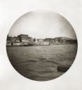
| Date: | 05 10 1894 |
|---|---|
| Description: | View of a wharf from the river, with a bit of an oar visible in the foreground. There is a ferry with the name Liberty on the shoreline. A row of bu... |
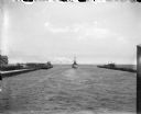
| Date: | 07 1899 |
|---|---|
| Description: | A boat leaving Milwaukee Harbor between two breakwaters, steaming into Milwaukee Bay and onward out into Lake Michigan. |
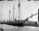
| Date: | 1898 |
|---|---|
| Description: | A large sailing ship docked in Milwaukee Harbor. |

| Date: | 1857 |
|---|---|
| Description: | This map of Sheboygan Harbor shows the river mouth and harbor, piers, wharfs, piles of old destroyed bridge wharfs, streets, and the lake shore from survey... |

| Date: | 1890 |
|---|---|
| Description: | The "J.C. Ames," a Lake Michigan car ferry, probably in the South Chicago harbor. There is a railroad bridge visible in the background. |
| Date: | 1897 |
|---|---|
| Description: | View from shoreline of replicas of the Niña, Pinta and Santa Maria docked in a harbor among many boats. |

| Date: | 1874 |
|---|---|
| Description: | Engraved view of downtown Racine seen from Lake Michigan. Several vessels are entering the harbor, and a pier with a beacon is on the right. |

| Date: | 1871 |
|---|---|
| Description: | Engraved view of Kenosha harbor. A group of men fish from a pier in the foreground while several boats float through the harbor. A tug is pulling a large s... |

| Date: | 07 19 1854 |
|---|---|
| Description: | This map shows the shore in 1844, 1850, and 1852, the length of and proposed additions to the pier. Relief is shown by hachures and depths are shown by sou... |

| Date: | 07 19 1854 |
|---|---|
| Description: | This hand-colored map shows the North and South Pier, the North Pier Bridge, the present Channel, and the Channel to be dredged. Lake Michigan and a light ... |

| Date: | 1857 |
|---|---|
| Description: | This map with north oriented toward the lower left shows the United States North and South Piers. Lake shores from 1855, 1856, and 1857 are labeled. Depths... |

| Date: | 09 1853 |
|---|---|
| Description: | This map shows streets, docks, warehouses, and piers near the harbor. The Manitowoc River and Lake Michigan are labeled. Depths are indicated by soundings ... |

| Date: | 1854 |
|---|---|
| Description: | This map shows streets, docks, warehouses, and piers near the harbor. Relief is shown by hachures and depths are shown by soundings and isolines. Lake Mich... |
If you didn't find the material you searched for, our Library Reference Staff can help.
Call our reference desk at 608-264-6535 or email us at:
