 Filter: Categories of Wisconsin Historical Images
Filter: Subject of Harbors
Filter: Year of 1800-1899
Filter: Subject of architecture
Filter: Categories of Wisconsin Historical Images
Filter: Subject of Harbors
Filter: Year of 1800-1899
Filter: Subject of architecture

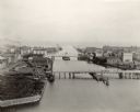
| Date: | 1857 |
|---|---|
| Description: | From Judge Smith Addition, 5th Ward, looking north, toward the city. Drawing is an elevated view of field and plank fence in foreground, road to the left a... |

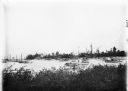
| Date: | 1886 |
|---|---|
| Description: | Bird's-eye view of Milwaukee from Bay View. |

| Date: | 1892 |
|---|---|
| Description: | Bird's-eye view of Chicago, with ships in the Lake Michigan harbor. |
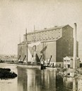
| Date: | 1870 |
|---|---|
| Description: | The Milwaukee & St. Paul Railway Company grain elevator at the Milwaukee harbor, with a sailing ship anchored nearby. |
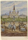
| Date: | 1859 |
|---|---|
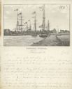
| Description: | On an excursion to the South in November 1859, Hölzlhuber made the three-day trip on the steamboat Planet from St. Louis to New Orleans. In the harb... |

| Date: | 1892 |
|---|---|
| Description: | Bird's-eye view of the Columbian Exposition pavilions from the vantage point of Lake Michigan. Included is an inset of the Union Passenger Station (now Uni... |

| Date: | 01 04 1862 |
|---|---|
| Description: | Engraving of the city of Superior and Lake Superior, also depicting railroad piers, Minnesota Point, and the steamboat "Star". The engraving appears on a l... |

| Date: | 1880 |
|---|---|
| Description: | Map of Wisconsin including the eastern portions on Minnesota, Iowa, northern Illinois, and the western most portion of Michigan’s Upper Peninsula, showing ... |
| Date: | 1897 |
|---|---|
| Description: | View from shoreline of replicas of the Niña, Pinta and Santa Maria docked in a harbor among many boats. |

| Date: | 1871 |
|---|---|
| Description: | Engraved view of Kenosha harbor. A group of men fish from a pier in the foreground while several boats float through the harbor. A tug is pulling a large s... |

| Date: | 07 19 1854 |
|---|---|
| Description: | This map shows the shore in 1844, 1850, and 1852, the length of and proposed additions to the pier. Relief is shown by hachures and depths are shown by sou... |

| Date: | 1854 |
|---|---|
| Description: | This map shows bay and harbor soundings, the Milwaukee River, and select buildings. Depths are shown by soundings and relief is shown by hachures. The top ... |

| Date: | 1873 |
|---|---|
| Description: | This blueprint map shows water depths by soundings and isolines. To the top left is Duluth, Minnesota. To the bottom right is Superior City, Wisconsin. The... |
| Date: | 1898 |
|---|---|
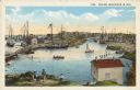
| Description: | Bird's-eye view of the Manitowoc Harbor facing east from Northern Grain Company's Elevator B. In the foreground, Mathews & Keith's pile driver scow is secu... |
| Date: | 1850 |
|---|---|
| Description: | Text on front reads: "Racine, Wisconsin in 1850." Artist's rendering of the view of the harbor with sailing ships, sailboats, rowboats and canoes. The Main... |
| Date: | 1856 |
|---|---|
| Description: | Lithograph image of several boats in a harbor. Most are flying American flags from their masts. One has a flag on which "C. Harrison" is printed. Someone h... |
If you didn't find the material you searched for, our Library Reference Staff can help.
Call our reference desk at 608-264-6535 or email us at:
