 Filter: Categories of Wisconsin Historical Images
Filter: Subject of Harbors
Filter: Subject of rivers
Filter: Subject of land
Filter: Categories of Wisconsin Historical Images
Filter: Subject of Harbors
Filter: Subject of rivers
Filter: Subject of land

| Date: | 1913 |
|---|---|
| Description: | Bird's-eye map of Superior. "The New Steel Center." |

| Date: | 1892 |
|---|---|
| Description: | Bird's-eye view of Chicago, with ships in the Lake Michigan harbor. |

| Date: | 1892 |
|---|---|
| Description: | Bird's-eye view of the Columbian Exposition pavilions from the vantage point of Lake Michigan. Included is an inset of the Union Passenger Station (now Uni... |

| Date: | 1876 |
|---|---|
| Description: | Made from U.S. Surveys and from minutes furnished by Jos. S. Buck and Dr. C. Chase. Scale 20 CHs to an inch. |

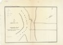
| Date: | 1853 |
|---|---|
| Description: | Plan no. 3. Scale 2000 feet to one inch. |
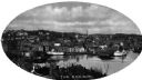
| Date: | |
|---|---|
| Description: | Elevated view of Norwich harbor. Oval-framed view features two ships in the river harbor as well as buildings on the waterfront and on the surrounding hill... |

| Date: | 1880 |
|---|---|
| Description: | Map of Wisconsin including the eastern portions on Minnesota, Iowa, northern Illinois, and the western most portion of Michigan’s Upper Peninsula, showing ... |

| Date: | 1876 |
|---|---|
| Description: | This 1876 map shows the mouth of the Ahnapee River at Algoma, Kewaunee County, Wisconsin, with soundings given in tenths of a foot. Proposed improvements a... |

| Date: | 1836 |
|---|---|
| Description: | This map is pen-and-ink on paper and shows marshlands, rivers, creeks, a quarry, and a few roads. |

| Date: | 1961 |
|---|---|
| Description: | This map shows established harbor lines, local streets, railroads, U.S. government channel, and part of Fox River. The map includes a table of reference po... |

| Date: | 01 08 1958 |
|---|---|
| Description: | Elevated view over icy water towards ships in the shipyard on the left, and the cement company in the background. Cranes and industrial buildings are in th... |

| Date: | |
|---|---|
| Description: | Aerial view of harbor. In the foreground is a lighthouse and breakwaters. Bridges cross the harbor, and there are factory and industrial buildings near the... |

| Date: | 1867 |
|---|---|
| Description: | This map shows components of the bottom of Lake Michigan and the Root River, as well as the harbor, buildings, streets, railroads, and rural landowners in ... |

| Date: | 1854 |
|---|---|
| Description: | This map shows bay and harbor soundings, the Milwaukee River, and select buildings. Depths are shown by soundings and relief is shown by hachures. The top ... |
| Date: | 1854 |
|---|---|
| Description: | This map is oriented with north slightly to the right and the Milwaukee River is labeled. The top margin reads: "Senate Ex. Doc. No. 1. 1st Session, 33rd C... |

| Date: | 1831 |
|---|---|
| Description: | This map shows the land that makes up Michigan, Wisconsin, Minnesota, Indiana, and parts of Canada. The Great Lakes are displayed prominently, along with s... |

| Date: | 1630 |
|---|---|
| Description: | One of the few maps by Dutch cartographer Willem Blaeu depicting the Americas, this map shows regions, settlements, islands, mountains, forests, rivers, an... |

| Date: | 1733 |
|---|---|
| Description: | This map of North America shows settlements, rivers, lakes, Native American land, trade winds, and numerous topographical features such as forests and moun... |

| Date: | 1795 |
|---|---|
| Description: | Map of Maine, showing a few cities, harbors, hills, mountains, lakes, and rivers. A road runs from Pownalboro south to Portsmouth harbor, and the boundary ... |

| Date: | 11 1781 |
|---|---|
| Description: | Map of New York, Staten Island, and Long Island, showing the placements of forts, and the movement of troops in 1776. The map also includes towns, cities, ... |
If you didn't find the material you searched for, our Library Reference Staff can help.
Call our reference desk at 608-264-6535 or email us at: