 Filter: Categories of Wisconsin Historical Images
Filter: Subject of Harbors
Filter: Subject of rivers
Filter: Subject of hills
Filter: Categories of Wisconsin Historical Images
Filter: Subject of Harbors
Filter: Subject of rivers
Filter: Subject of hills

| Date: | 1913 |
|---|---|
| Description: | Bird's-eye map of Superior. "The New Steel Center." |
| Date: | |
|---|---|
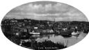
| Description: | Elevated view of Norwich harbor. Oval-framed view features two ships in the river harbor as well as buildings on the waterfront and on the surrounding hill... |

| Date: | 01 08 1958 |
|---|---|
| Description: | Elevated view over icy water towards ships in the shipyard on the left, and the cement company in the background. Cranes and industrial buildings are in th... |

| Date: | 1795 |
|---|---|
| Description: | Map of Maine, showing a few cities, harbors, hills, mountains, lakes, and rivers. A road runs from Pownalboro south to Portsmouth harbor, and the boundary ... |

| Date: | 11 1781 |
|---|---|
| Description: | Map of New York, Staten Island, and Long Island, showing the placements of forts, and the movement of troops in 1776. The map also includes towns, cities, ... |
If you didn't find the material you searched for, our Library Reference Staff can help.
Call our reference desk at 608-264-6535 or email us at: