 Filter: Categories of Wisconsin Historical Images
Filter: Subject of Harbors
Filter: Subject of ocean
Filter: Subject of cities and towns
Filter: Categories of Wisconsin Historical Images
Filter: Subject of Harbors
Filter: Subject of ocean
Filter: Subject of cities and towns
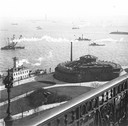
| Date: | 1900 |
|---|---|
| Description: | Elevated view, probably early 20th century New York Harbor. |
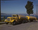
| Date: | 1951 |
|---|---|
| Description: | Color photograph of an International LD-400 series tanker truck owned by Eastern Washington Transports, Inc., on a road near the Port of Seattle. |

| Date: | |
|---|---|
| Description: | Panoramic collotype of Havana, Cuba harbor. Numerous boats are visible. Sky appears to have been masked out before printing. |

| Date: | |
|---|---|
| Description: | Elevated view of village homes on the shores of the bay with docked fishing boats in the foreground. Caption reads, "Marblehead, Mass from Rockmere Point." |
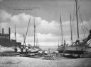
| Date: | |
|---|---|
| Description: | View of a group of people posed near several oyster boats under repair on the shore. Some buildings are on the left side. A sign on the boat on the far rig... |

| Date: | |
|---|---|
| Description: | Aerial view of a developed strip of land on Barnegat Bay showing the Atlantic ocean, houses, lakes, railroad tracks, a marina and a jetty in the distance. |

| Date: | 1968 |
|---|---|
| Description: | A man walking with a cane in the sand dunes on Coney Island. A dilapidated fence cuts across the foreground of the beach and a rock jetty juts into the ba... |

| Date: | 1959 |
|---|---|
| Description: | Aerial view of the island of Cuba taken from a small plane. Part of the plane with a Cuban flag painted on it is in the frame, and the island with many bui... |

| Date: | 02 05 1944 |
|---|---|
| Description: | General view of Port Moresby Harbor from road, New Guinea (present day Papua New Guinea). A jeep is on the road on the left. Several soldiers are near a sh... |

| Date: | 1715 |
|---|---|
| Description: | A map of the countries and islands surrounding the Gulf of Mexico. The hand-colored borders separate the territories of England, France, Spain, and Holland... |

| Date: | 1720 |
|---|---|
| Description: | One of Herman Moll's most famous maps, often referred to as The Beaver Map for its elaborate engraved inset depicting and describing beavers building a dam... |

| Date: | 1715 |
|---|---|
| Description: | One of Herman Moll's most famous maps, often referred to as The Codfish Map, it shows rivers and portages, cities, Indian villages, wind directions, routes... |

| Date: | 1719 |
|---|---|
| Description: | Map of the British colonies and territories in North American, depicting cities, Native American land, rivers, mines, forts, trees, and topography east of ... |

| Date: | 1720 |
|---|---|
| Description: | This map of North America shows cities, rivers, lakes, and a few topographical features, complete with numerous descriptive blocks of text about expedition... |

| Date: | 1630 |
|---|---|
| Description: | One of the few maps by Dutch cartographer Willem Blaeu depicting the Americas, this map shows regions, settlements, islands, mountains, forests, rivers, an... |

| Date: | 1733 |
|---|---|
| Description: | This map of North America shows settlements, rivers, lakes, Native American land, trade winds, and numerous topographical features such as forests and moun... |

| Date: | 1853 |
|---|---|
| Description: | A map of Wellfleet Harbor on Cape Cod Bay. |
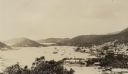
| Date: | 03 1913 |
|---|---|
| Description: | Elevated view of the harbor at Charlotte Amalie, St. Thomas. Sailing vessels of various sizes are moored in the harbor. There are islands in the background... |
If you didn't find the material you searched for, our Library Reference Staff can help.
Call our reference desk at 608-264-6535 or email us at: