 Filter: Categories of Wisconsin Historical Images
Filter: Subject of Harbors
Filter: Subject of military bases
Filter: Categories of Wisconsin Historical Images
Filter: Subject of Harbors
Filter: Subject of military bases
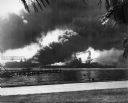
| Date: | 12 07 1941 |
|---|---|
| Description: | The USS Nevada in berth at Pearl Harbor with the USS Shaw burning in the background after its forward deck was hit with a Japanese bomb. |
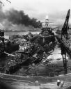
| Date: | 12 07 1941 |
|---|---|
| Description: | The remains of the USS Cassin and the USS Downes floating in front of the USS Pennsylvania in dock at Pearl Harbor. On the left is th... |

| Date: | 12 07 1941 |
|---|---|
| Description: | Sailors in a motor launch attempt a rescue of survivors from the water alongside the sunken battleship USS West Virginia during or shortly after the... |
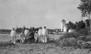
| Date: | 1915 |
|---|---|
| Description: | Six Coastguardsmen pose with an officer on the shore at the Coast Guard Station at Baileys Harbor. The men are identified as (left to right) Reinhart Hicke... |
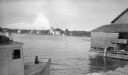
| Date: | 1915 |
|---|---|
| Description: | The Baileys Harbor Coast Guard Life Saving Station viewed from between a fishing boat and a pier warehouse. The station's pier extends into the harbor and ... |
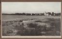
| Date: | 1915 |
|---|---|
| Description: | View from shoreline over water towards the Coast Guard Station and houses at Baileys Harbor. The long pier extending from the station's boathouse is easily... |

| Date: | 02 05 1944 |
|---|---|
| Description: | General view of Port Moresby Harbor from road, New Guinea (present day Papua New Guinea). A jeep is on the road on the left. Several soldiers are near a sh... |

| Date: | 02 05 1944 |
|---|---|
| Description: | View from road of the exterior of the Allied Officers' Club in Port Moresby, New Guinea (present day Papua New Guinea). It is built on posts above the wate... |

| Date: | 1777 |
|---|---|
| Description: | Map showing the Hudson River in three sections, from New York City up through Lake Champlain, including cities, forts, roads, topographical features, and n... |

| Date: | 11 1781 |
|---|---|
| Description: | Map of New York, Staten Island, and Long Island, showing the placements of forts, and the movement of troops in 1776. The map also includes towns, cities, ... |
If you didn't find the material you searched for, our Library Reference Staff can help.
Call our reference desk at 608-264-6535 or email us at: