 Filter: Categories of Wisconsin Historical Images
Filter: Subject of Harbors
Filter: Subject of land use, urban
Filter: Categories of Wisconsin Historical Images
Filter: Subject of Harbors
Filter: Subject of land use, urban

| Date: | 1892 |
|---|---|
| Description: | Bird's-eye view of Chicago, with ships in the Lake Michigan harbor. |
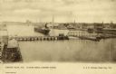
| Date: | 1900 |
|---|---|
| Description: | Looking North. Harbor with boats, bridge, and buildings. |
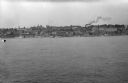
| Date: | |
|---|---|
| Description: | Elevated view of the harbor skyline, with the city on the horizon. |

| Date: | 1917 |
|---|---|
| Description: | World War I poster urging newly arrived immigrants to conserve food to aid the allied cause. People in ethnic costume being ushered into the United States ... |

| Date: | 1964 |
|---|---|
| Description: | This map of Two Rivers shows the Rodgers street fishing area and land use. The map features a legend on the right of the types of land use. The map also sh... |

| Date: | 1715 |
|---|---|
| Description: | A map of the countries and islands surrounding the Gulf of Mexico. The hand-colored borders separate the territories of England, France, Spain, and Holland... |
If you didn't find the material you searched for, our Library Reference Staff can help.
Call our reference desk at 608-264-6535 or email us at:
