 Filter: Categories of Wisconsin Historical Images
Filter: Subject of Harbors
Filter: Subject of industries
Filter: Subject of rivers
Filter: Categories of Wisconsin Historical Images
Filter: Subject of Harbors
Filter: Subject of industries
Filter: Subject of rivers

| Date: | 1913 |
|---|---|
| Description: | Bird's-eye map of Superior. "The New Steel Center." |
| Date: | 03 19 1940 |
|---|---|
| Description: | View across Milwaukee River of workers of the Herman M. Hettler Lumber Company unloading lumber off a shipping boat to the Shroeder Lumber Yards and Troste... |
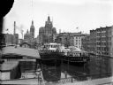
| Date: | |
|---|---|
| Description: | Elevated view of two Goodrich Line passenger ferries docked on the west bank of the Milwaukee River, north of the Clybourn Street bridge. The Pabst buildin... |
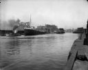
| Date: | |
|---|---|
| Description: | Steamboat "Thomas Mattham" in the Milwaukee harbor being pulled by a tugboat from the north bank near Erie Street. |
| Date: | 07 17 1914 |
|---|---|
| Description: | Steamboat "E.L. Wallace" on the Menominee River looking east from the 16th Street viaduct. Coal yards are on the banks of the harbor. |
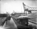
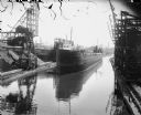
| Date: | 07 17 1914 |
|---|---|
| Description: | Menominee River coal yards, west from the 16th Street viaduct. There is a cargo ship called the "John B. Cowle" in the harbor between two coal yards. Worke... |

| Date: | 1836 |
|---|---|
| Description: | This map is pen-and-ink on paper and shows marshlands, rivers, creeks, a quarry, and a few roads. |

| Date: | 1964 |
|---|---|
| Description: | This map of Two Rivers shows the Rodgers street fishing area and land use. The map features a legend on the right of the types of land use. The map also sh... |

| Date: | 1901 |
|---|---|
| Description: | This map shows streets, industrial buildings, a portion of Lake Superior and other lakes, bays, and rivers in portions of Duluth and Superior. Relief is sh... |

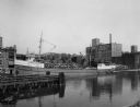
| Date: | 01 08 1958 |
|---|---|
| Description: | Elevated view over icy water towards ships in the shipyard on the left, and the cement company in the background. Cranes and industrial buildings are in th... |

| Date: | 1854 |
|---|---|
| Description: | This map shows streets, docks, warehouses, and piers near the harbor. Relief is shown by hachures and depths are shown by soundings and isolines. Lake Mich... |

| Date: | 1923 |
|---|---|
| Description: | This map shows major cities surrounding the Great Lakes. Portions of Minnesota, Iowa, Illinois, Indiana, Ohio, Michigan, New York, Vermont, Massachusetts,C... |
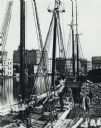
| Date: | 1875 |
|---|---|
| Description: | Elevated view of a deck of a schooner hauling lumber. Several workmen are loading or unloading the lumber. Industrial buildings, some displaying signs, are... |

| Date: | 1719 |
|---|---|
| Description: | Map of the British colonies and territories in North American, depicting cities, Native American land, rivers, mines, forts, trees, and topography east of ... |
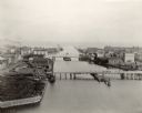
| Date: | 1898 |
|---|---|
| Description: | Bird's-eye view of the Manitowoc Harbor facing east from Northern Grain Company's Elevator B. In the foreground, Mathews & Keith's pile driver scow is secu... |
If you didn't find the material you searched for, our Library Reference Staff can help.
Call our reference desk at 608-264-6535 or email us at: