Filter: Categories of Wisconsin Historical Images
Filter: Subject of Harbors
Filter: Subject of human settlements
Filter: Categories of Wisconsin Historical Images
Filter: Subject of Harbors
Filter: Subject of human settlements
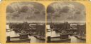
| Date: | 1907 |
|---|---|
| Description: | View across Fish Creek Harbor to the village of Fish Creek and its pier, with warehouse. On the right is Dr. Weckler's Resort, a large wooden building with... |
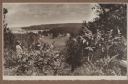
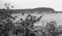
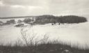
| Date: | 1920 |
|---|---|
| Description: | A well-dressed man identified as Uncle Rudolph Schenck takes in the view from a bluff overlooking the Fish Creek valley and harbor. There are houses and ou... |
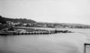
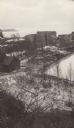
| Date: | 1924 |
|---|---|
| Description: | Elevated view over water of the harbor and buildings of Frankfort. There is a deteriorating pier in the foreground. |
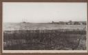
| Date: | 02 1925 |
|---|---|
| Description: | Elevated view of the abandoned town of Fayette. Snail Shell Harbor is in the foreground, with a low warehouse along the boat dock and empty buildings on th... |
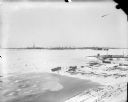
| Date: | 02 1925 |
|---|---|
| Description: | Elevated view of the abandoned Jackson Iron Company furnace complex at Fayette, on the shore of Snail Shell Harbor. Lake Michigan is in the background. |

| Date: | 1874 |
|---|---|
| Description: | Engraved view of downtown Racine seen from Lake Michigan. Several vessels are entering the harbor, and a pier with a beacon is on the right. |

| Date: | 1876 |
|---|---|
| Description: | This 1876 map shows the mouth of the Ahnapee River at Algoma, Kewaunee County, Wisconsin, with soundings given in tenths of a foot. Proposed improvements a... |

| Date: | 1871 |
|---|---|
| Description: | Asaph Whittlesey arrived in Ashland in 1854, one of the earliest of the settlers who hoped the area would grow and make their fortunes. He drew this map of... |

| Date: | 1900 |
|---|---|
| Description: | This chart of the northern Apostle Islands and Lake Superior shoreline shows relief by contours and spot heights and depths by contours, gradient tints and... |

| Date: | 1871 |
|---|---|
| Description: | Asaph Whittlesey arrived in Ashland in 1854, one of the earliest of the settlers who hoped the area would grow and make their fortunes. He drew this map of... |
| Date: | 1915 |
|---|---|
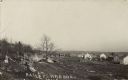
| Description: | View from shoreline over water towards a three-masted sailing vessel docked at Baileys Harbor pier. Houses and commercial buildings line the shore. |

| Date: | 05 1958 |
|---|---|
| Description: | Photocopy of a map created by the City of Milwaukee Master Plan Program City Planning Division in May of 1958 representing 1870 "THE CENTRAL AREA OF THE CI... |

| Date: | 02 05 1944 |
|---|---|
| Description: | General view of Port Moresby Harbor from road, New Guinea (present day Papua New Guinea). A jeep is on the road on the left. Several soldiers are near a sh... |
| Date: | 1918 |
|---|---|
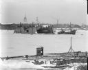
| Description: | View of Solombola from Archangel [Archangelsk], Russia. In the distance are series of cranes. In the foreground on the ice are stacks of logs near a pier m... |
| Date: | 1918 |
|---|---|
| Description: | View over pier made of pilings towards a floating drydock, now embedded in the ice, near Solombola, Russia. There are tall buildings behind it on the oppos... |

| Date: | 1918 |
|---|---|
| Description: | Elevated view looking down gutter of roof towards the British volunteer forces parading in Archangel [Archangelsk], Russia right before they disembarked fr... |

| Date: | 1918 |
|---|---|
| Description: | Elevated view from roof of British volunteer forces parading in Archangel [Archangelsk], Russia right before they disembarked from the town. The crowd watc... |
| Date: | 1910 |
|---|---|
| Description: | Photographic postcard view across rocky field of dwellings and other buildings along Lake Michigan. Along the left is a rocky ledge. The shoreline of the h... |

| Date: | 1972 |
|---|---|
| Description: | Aerial view of commercial buildings and dwellings along the shore of Lake Michigan. Caption reads: "Baileys Harbor, Wisc." |
If you didn't find the material you searched for, our Library Reference Staff can help.
Call our reference desk at 608-264-6535 or email us at: