 Filter: Categories of Wisconsin Historical Images
Filter: Subject of Harbors
Filter: Subject of hills
Filter: Subject of intellectual life
Filter: Categories of Wisconsin Historical Images
Filter: Subject of Harbors
Filter: Subject of hills
Filter: Subject of intellectual life

| Date: | 1913 |
|---|---|
| Description: | Bird's-eye map of Superior. "The New Steel Center." |

| Date: | 1795 |
|---|---|
| Description: | Map of Maine, showing a few cities, harbors, hills, mountains, lakes, and rivers. A road runs from Pownalboro south to Portsmouth harbor, and the boundary ... |
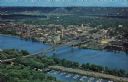
| Date: | |
|---|---|
| Description: | Photographic postcard of an aerial view over La Crosse and the I-90 Interstate bridge. French Island is in the foreground. |
If you didn't find the material you searched for, our Library Reference Staff can help.
Call our reference desk at 608-264-6535 or email us at: