 Filter: Categories of Wisconsin Historical Images
Filter: Subject of Harbors
Filter: Subject of coasts
Filter: Categories of Wisconsin Historical Images
Filter: Subject of Harbors
Filter: Subject of coasts
| Date: | 1920 |
|---|---|
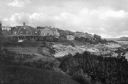
| Description: | View along top of cliff toward cottages along a rocky coast. A large building is in the distance on the right. |

| Date: | |
|---|---|
| Description: | Hand-drawn map of the area at the time of Pilgrim landing, drawn by Charles Blaskowikz. Includes commemorative historical notes. |

| Date: | 1951 |
|---|---|
| Description: | This map is a survey of Lake Michigan and the section of Milwaukee that borders the lake. Map of land includes major streets, and landmarks near water. Rel... |

| Date: | |
|---|---|
| Description: | Aerial view of harbors and bridge. Farm fields are on either side of the bridge. The city of Sturgeon Bay is in the distance. There are docks along the sho... |

| Date: | 1795 |
|---|---|
| Description: | Map of Maine, showing a few cities, harbors, hills, mountains, lakes, and rivers. A road runs from Pownalboro south to Portsmouth harbor, and the boundary ... |

| Date: | 11 1781 |
|---|---|
| Description: | Map of New York, Staten Island, and Long Island, showing the placements of forts, and the movement of troops in 1776. The map also includes towns, cities, ... |

| Date: | 1763 |
|---|---|
| Description: | Map showing the new British territories of East and West Florida following the Treaty of Paris at the end of the French and Indian War. It shows boundaries... |

| Date: | 1814 |
|---|---|
| Description: | A map of the Harbour (sic) of St. Catherine (Brazil). |
If you didn't find the material you searched for, our Library Reference Staff can help.
Call our reference desk at 608-264-6535 or email us at: