Filter: Categories of Wisconsin Historical Images
Filter: Subject of Harbors
Filter: Subject of cities and towns
Filter: Subject of water
Filter: Categories of Wisconsin Historical Images
Filter: Subject of Harbors
Filter: Subject of cities and towns
Filter: Subject of water

| Date: | |
|---|---|
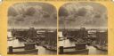
| Description: | View of the wharf and city from the harbor. Men stand on the main pier beside warehouses. |

| Date: | 1857 |
|---|---|
| Description: | This map of Sheboygan Harbor shows the river mouth and harbor, piers, wharfs, piles of old destroyed bridge wharfs, streets, and the lake shore from survey... |
| Date: | 1957 |
|---|---|
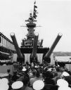
| Description: | Ceremony beneath the guns on board the U.S.S. Wisconsin. A number of spectators and sailors are seated in the foreground, and uniformed sailors line... |

| Date: | 1880 |
|---|---|
| Description: | Map of Wisconsin including the eastern portions on Minnesota, Iowa, northern Illinois, and the western most portion of Michigan’s Upper Peninsula, showing ... |
| Date: | 02 1924 |
|---|---|
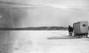
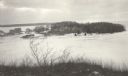
| Description: | A single horse pulls an enclosed sleigh across a frozen Door County harbor. Houses and a church are visible onshore. |
| Date: | 1925 |
|---|---|
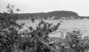
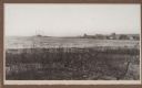
| Description: | Elevated view of Fish Creek from the east; the bluff rises on the left, the harbor is on the right. The cottage in the foreground with pergola and lattice ... |
| Date: | 1897 |
|---|---|
| Description: | View from shoreline of replicas of the Niña, Pinta and Santa Maria docked in a harbor among many boats. |
| Date: | 1907 |
|---|---|
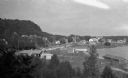
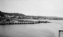
| Description: | View across Fish Creek Harbor to the village of Fish Creek and its pier, with warehouse. On the right is Dr. Weckler's Resort, a large wooden building with... |
| Date: | 1920 |
|---|---|
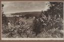
| Description: | A well-dressed man identified as Uncle Rudolph Schenck takes in the view from a bluff overlooking the Fish Creek valley and harbor. There are houses and ou... |
| Date: | 1924 |
|---|---|
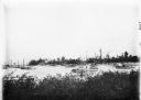
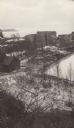
| Description: | Elevated view over water of the harbor and buildings of Frankfort. There is a deteriorating pier in the foreground. |
| Date: | 02 1925 |
|---|---|
| Description: | Elevated view of the abandoned town of Fayette. Snail Shell Harbor is in the foreground, with a low warehouse along the boat dock and empty buildings on th... |
| Date: | 02 1925 |
|---|---|
| Description: | Elevated view of the abandoned Jackson Iron Company furnace complex at Fayette, on the shore of Snail Shell Harbor. Lake Michigan is in the background. |

| Date: | 1874 |
|---|---|
| Description: | Engraved view of downtown Racine seen from Lake Michigan. Several vessels are entering the harbor, and a pier with a beacon is on the right. |

| Date: | 1876 |
|---|---|
| Description: | This 1876 map shows the mouth of the Ahnapee River at Algoma, Kewaunee County, Wisconsin, with soundings given in tenths of a foot. Proposed improvements a... |

| Date: | 1871 |
|---|---|
| Description: | Asaph Whittlesey arrived in Ashland in 1854, one of the earliest of the settlers who hoped the area would grow and make their fortunes. He drew this map of... |

| Date: | 1900 |
|---|---|
| Description: | This chart of the northern Apostle Islands and Lake Superior shoreline shows relief by contours and spot heights and depths by contours, gradient tints and... |

| Date: | 1871 |
|---|---|
| Description: | Asaph Whittlesey arrived in Ashland in 1854, one of the earliest of the settlers who hoped the area would grow and make their fortunes. He drew this map of... |
| Date: | 1915 |
|---|---|
| Description: | View from shoreline over water towards a three-masted sailing vessel docked at Baileys Harbor pier. Houses and commercial buildings line the shore. |

| Date: | 02 05 1944 |
|---|---|
| Description: | General view of Port Moresby Harbor from road, New Guinea (present day Papua New Guinea). A jeep is on the road on the left. Several soldiers are near a sh... |
If you didn't find the material you searched for, our Library Reference Staff can help.
Call our reference desk at 608-264-6535 or email us at: