Filter: Categories of Wisconsin Historical Images
Filter: Subject of Harbors
Filter: Subject of cities and towns
Filter: Subject of military art and science
Filter: Categories of Wisconsin Historical Images
Filter: Subject of Harbors
Filter: Subject of cities and towns
Filter: Subject of military art and science
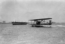
| Date: | 1912 |
|---|---|
| Description: | A hydroplane built by the Wright Brothers being tested by the U.S. Navy on San Diego Bay. |

| Date: | |
|---|---|
| Description: | Elevated view of Fort Seward from Mount Rippinsky, showing Pyramid Harbor and Davidson Glacier in distance. Caption reads: "Haines and Fort Wm. H. Seward f... |
| Date: | |
|---|---|
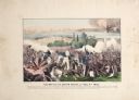
| Description: | A large color lithograph with caption of the battle in progress. |

| Date: | 1917 |
|---|---|
| Description: | World War I poster urging newly arrived immigrants to conserve food to aid the allied cause. People in ethnic costume being ushered into the United States ... |

| Date: | 1913 |
|---|---|
| Description: | Elevated view of shoreline, waterfront buildings, boat-dotted bay and Perry's Victory and International Peace Memorial. The pink-marble, column-shaped monu... |
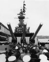
| Date: | 1957 |
|---|---|
| Description: | Ceremony beneath the guns on board the U.S.S. Wisconsin. A number of spectators and sailors are seated in the foreground, and uniformed sailors line... |

| Date: | 02 05 1944 |
|---|---|
| Description: | General view of Port Moresby Harbor from road, New Guinea (present day Papua New Guinea). A jeep is on the road on the left. Several soldiers are near a sh... |

| Date: | 1918 |
|---|---|
| Description: | Elevated view looking down gutter of roof towards the British volunteer forces parading in Archangel [Archangelsk], Russia right before they disembarked fr... |

| Date: | 1918 |
|---|---|
| Description: | Elevated view from roof of British volunteer forces parading in Archangel [Archangelsk], Russia right before they disembarked from the town. The crowd watc... |
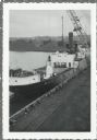
| Date: | |
|---|---|
| Description: | Elevated view over railroads tracks of Canadian ship with cargo of wood pulp. Sulphide bales are being unloaded and there are several men on the ship. In t... |

| Date: | 1905 |
|---|---|
| Description: | This map shows a plat of the city, local streets, railroads, public buildings, local businesses, and parts of the Manitowoc River and Lake Michigan. Relief... |

| Date: | 1925 |
|---|---|
| Description: | This map shows a plat of the city, local streets, railroads, public buildings, local businesses, and parts of the Manitowoc River and Lake Michigan. Relief... |

| Date: | 1777 |
|---|---|
| Description: | Map showing the Hudson River in three sections, from New York City up through Lake Champlain, including cities, forts, roads, topographical features, and n... |

| Date: | 1733 |
|---|---|
| Description: | This map of North America shows settlements, rivers, lakes, Native American land, trade winds, and numerous topographical features such as forests and moun... |

| Date: | 11 1781 |
|---|---|
| Description: | Map of New York, Staten Island, and Long Island, showing the placements of forts, and the movement of troops in 1776. The map also includes towns, cities, ... |

| Date: | 02 01 1919 |
|---|---|
| Description: | View from ship as a crowd on a pier is saying goodbye to "Espagne" as it is sailing away. Captioned: "The crowd at the pier as the 'Espagne' left for Borde... |

| Date: | |
|---|---|
| Description: | Bombardment of the harbor of Novo Rossijsk (Novorossisk) by the light cruiser "S.M.S. Breslau, now the "Midilli." The white smoke in the center is from an ... |

| Date: | |
|---|---|
| Description: | Antivari (Bar) was the primary port city of Montenegro. |
If you didn't find the material you searched for, our Library Reference Staff can help.
Call our reference desk at 608-264-6535 or email us at: