 Filter: Categories of Wisconsin Historical Images
Filter: Subject of Harbors
Filter: Subject of bridges
Filter: Subject of streets
Filter: Categories of Wisconsin Historical Images
Filter: Subject of Harbors
Filter: Subject of bridges
Filter: Subject of streets

| Date: | 1892 |
|---|---|
| Description: | Bird's-eye view of Chicago, with ships in the Lake Michigan harbor. |

| Date: | 1907 |
|---|---|
| Description: | This map is a chart of Milwaukee Harbor that displays local streets, bridges, roads, railroads, public buildings, businesses, factories, dry docks, parks, ... |
| Date: | 1898 |
|---|---|
| Description: | Bird's-eye view of the Manitowoc Harbor facing east from Northern Grain Company's Elevator B. In the foreground, Mathews & Keith's pile driver scow is secu... |

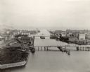
| Date: | 1922 |
|---|---|
| Description: | Text on front reads: "Aerial View of Sheboygan, Wis." The image shows the Sheboygan River from Lake Michigan to the Pennsylvania Avenue bridge. |

| Date: | 07 06 1931 |
|---|---|
| Description: | Text on front reads: "Where Green Bay and Sturgeon Bay Meet, Sturgeon Bay, Wis." Aerial view of Sturgeon Bay showing the only bridge in existence at the ti... |
If you didn't find the material you searched for, our Library Reference Staff can help.
Call our reference desk at 608-264-6535 or email us at: