 Filter: Categories of Wisconsin Historical Images
Filter: Subject of Harbors
Filter: County of Bayfield
Filter: Categories of Wisconsin Historical Images
Filter: Subject of Harbors
Filter: County of Bayfield

| Date: | 1910 |
|---|---|
| Description: | Bird's-eye view looking east, with Washburn Harbor at center and Chequamegon Bay in Lake Superior covering most of the upper image. Streets with buildings... |
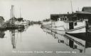
| Date: | |
|---|---|
| Description: | Fishing Fleet in the harbor. Caption reads: "The Cornucopia Fishing Fleet, Cornucopia, Wis." |

| Date: | 1871 |
|---|---|
| Description: | Asaph Whittlesey arrived in Ashland in 1854, one of the earliest of the settlers who hoped the area would grow and make their fortunes. He drew this map of... |

| Date: | 1871 |
|---|---|
| Description: | Asaph Whittlesey arrived in Ashland in 1854, one of the earliest of the settlers who hoped the area would grow and make their fortunes. He drew this map of... |
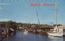
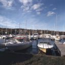
| Date: | |
|---|---|
| Description: | Photographic postcard view from water of a marina. Sailboats and motorboats are docked. More boats are stored up on the shoreline. Trees and buildings are ... |

| Date: | 1892 |
|---|---|
| Description: | This map of Bayfield shows roads, lots, and township boundaries. The map was originally published on one sheet but is now separated into front and back. On... |

| Date: | |
|---|---|
| Description: | Exterior of the menu for Paul's Cafe, with a bird's-eye view map of "Washburn's Natural Deep Water Land Locked Harbor," Chequamegon Bay, and the Apostle Is... |
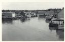
| Date: | 06 19 1958 |
|---|---|
| Description: | Slightly elevated view of Cornucopia Harbor. There is a boat moored at a pier near a barn-shaped building. An automobile is parked on the far left. In the ... |
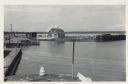
| Date: | 06 19 1958 |
|---|---|
| Description: | Slightly elevated view over water towards East slip in Cornucopia Harbor. There is a small cluster of buildings along the left and right sides with boats m... |
| Date: | 06 19 1958 |
|---|---|
| Description: | View over water towards storm damage in Cornucopia Harbor. West slip. There is a pile of wood along the shoreline in the foreground, with a boat moored jus... |
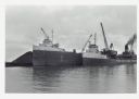
| Date: | |
|---|---|
| Description: | View across water towards ships unloading coal and sulphur. Cranes rise above both ships, and a man is walking near a large pile of coal in the background ... |
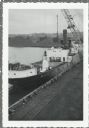
| Date: | |
|---|---|
| Description: | Elevated view over railroads tracks of Canadian ship with cargo of wood pulp. Sulphide bales are being unloaded and there are several men on the ship. In t... |
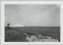
| Date: | |
|---|---|
| Description: | View from shoreline of dock site towards Lake Superior, showing sulphur pile and a large chute in the background. |
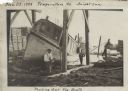
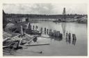
| Date: | 11 29 1908 |
|---|---|
| Description: | Men working on pulling the boat "Fish Hawk" out of the water. One man is kneeling in front of the boat and looking at the camera. A man in the background i... |
| Date: | 10 1978 |
|---|---|
| Description: | View from shoreline towards motorboats and sailboats docked in a marina. In the distance are buildings on a hill among trees. |
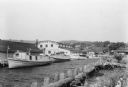
| Date: | 07 1936 |
|---|---|
| Description: | Fishing tugs are moored alongside the wharf at Bayfield. The large Bayfield Fish Co. building is identified in large letters on the end of the building. Th... |
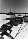
| Date: | 1976 |
|---|---|
| Description: | Fishing boats wintering on Lake Superior, which is frozen and covered with snow. Wooden fishing boxes are strewn in the foreground, and a wooded shoreline ... |
If you didn't find the material you searched for, our Library Reference Staff can help.
Call our reference desk at 608-264-6535 or email us at: