 Filter: Categories of Wisconsin Historical Images
Filter: Subject of Harbors
Filter: Community of Manitowoc
Filter: Subject of michigan, lake
Filter: Categories of Wisconsin Historical Images
Filter: Subject of Harbors
Filter: Community of Manitowoc
Filter: Subject of michigan, lake

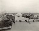
| Date: | 05 15 1897 |
|---|---|
| Description: | Elevated view of the Chicago & Northwestern Railway yards looking northwest. The elevator of the Northern Grain Company is in the middle distance. |
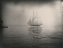
| Date: | 1890 |
|---|---|
| Description: | Schooner coming into Manitowoc harbor. |
| Date: | 07 02 1960 |
|---|---|
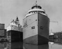
| Description: | View across water towards the Manitowoc Shipbuilding floating drydock. Pilings and grass are in the foreground. On the far shoreline are buildings on a hil... |

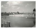
| Date: | 01 08 1958 |
|---|---|
| Description: | Elevated view from 8th Street Bridge over the Manitowoc River towards Lake Michigan. There is a lighthouse in the distance. Ice is floating on the water. A... |

| Date: | 01 08 1958 |
|---|---|
| Description: | Elevated view over icy water towards ships in the shipyard on the left, and the cement company in the background. Cranes and industrial buildings are in th... |

| Date: | 1905 |
|---|---|
| Description: | This map shows a plat of the city, local streets, railroads, public buildings, local businesses, and parts of the Manitowoc River and Lake Michigan. Relief... |

| Date: | 1925 |
|---|---|
| Description: | This map shows a plat of the city, local streets, railroads, public buildings, local businesses, and parts of the Manitowoc River and Lake Michigan. Relief... |

| Date: | 09 1853 |
|---|---|
| Description: | This map shows streets, docks, warehouses, and piers near the harbor. The Manitowoc River and Lake Michigan are labeled. Depths are indicated by soundings ... |

| Date: | 1854 |
|---|---|
| Description: | This map shows streets, docks, warehouses, and piers near the harbor. Relief is shown by hachures and depths are shown by soundings and isolines. Lake Mich... |

| Date: | 1856 |
|---|---|
| Description: | This map shows streets, piers, and wharves. Lake Michigan, the Manitowoc River, and select buildings are labeled. Relief is shown by hachures and sounding... |

| Date: | 1865 |
|---|---|
| Description: | This map shows the river shore and piers. Lake Michigan is labeled. Depths are shown by soundings and isolines. The bottom margin includes notes on soundi... |
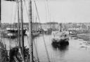
| Date: | |
|---|---|
| Description: | Elevated view of commercial boats in Manitowoc Harbor. |
| Date: | 1898 |
|---|---|
| Description: | Bird's-eye view of the Manitowoc Harbor facing east from Northern Grain Company's Elevator B. In the foreground, Mathews & Keith's pile driver scow is secu... |
| Date: | 04 1948 |
|---|---|
| Description: | Three lake steamers docked in the harbor. The closest steamer is the B.H. Taylor of the Bradley Transportation Company, transporting ores. Buildings are in... |
If you didn't find the material you searched for, our Library Reference Staff can help.
Call our reference desk at 608-264-6535 or email us at: