 Filter: Categories of Wisconsin Historical Images
Filter: Subject of Great Lakes
Filter: Categories of Wisconsin Historical Images
Filter: Subject of Great Lakes
| Date: | 09 26 2014 |
|---|---|
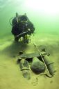
| Description: | Underwater view of an archaeologist surveying the bilge pump of the Success. The pump is resting in a bed of sand towards the stern of the ship. Tex... |

| Date: | 08 15 2014 |
|---|---|
| Description: | Underwater view of the capstan of the Success. The capstan is laying on its side embedded in the sand, near the stern on the starboard side of the s... |

| Date: | 08 15 2014 |
|---|---|
| Description: | Underwater view of the capstan on the scow schooner Success. It is laying on its side partially buried in sand. A section of the starboard side of t... |

| Date: | 1957 |
|---|---|
| Description: | This map shows the straights and rivers that connect the Great Lakes, as well as the proposed channels that have been authorized but not at the time of the... |

| Date: | 1936 |
|---|---|
| Description: | This map shows road surfaces, construction, flying fields, seaplane landings, populations of cities and towns, and ferry routes of Wisconsin and some of th... |

| Date: | 1937 |
|---|---|
| Description: | This map shows the major roads, cities, towns, lakes, and rivers of Wisconsin and some of the neighboring states. The front includes an add for Coca-Cola, ... |

| Date: | 1937 |
|---|---|
| Description: | This map shows the major cities, towns, highways, roads, lakes, and rivers of Wisconsin and some of the neighboring states. An index is included on the fro... |
| Date: | 1910 |
|---|---|
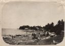
| Description: | View along shoreline of Weborg Point before the area became Peninsula State Park. Green Bay is on the left. Two wood buildings are along the shoreline in t... |
| Date: | 11 29 1908 |
|---|---|
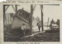
| Description: | Men working on pulling the boat "Fish Hawk" out of the water. One man is kneeling in front of the boat and looking at the camera. A man in the background i... |

| Date: | 08 2007 |
|---|---|
| Description: | Underwater view of the Apomattox's floor keelsons near the bow. |
| Date: | 2006 |
|---|---|
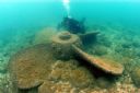
| Description: | Underwater view of a propeller located off of the Appomattox wreck site, near Shorewood, in Lake Michigan. The diver is Kimm Stabelfeldt. |

| Date: | 1881 |
|---|---|
| Description: | This map shows railroads, county boundaries, cities, towns, and waterways with relief shown by hachures. The prime meridians are: Greenwich and Washington.... |

| Date: | 1887 |
|---|---|
| Description: | This map shows railroads, county boundaries, cities, towns, and waterways with relief shown by hachures. The prime meridians are: Greenwich and Washington.... |

| Date: | 1872 |
|---|---|
| Description: | This map includes depth shown by soundings and isolines and relief shown by contours. Tree species and locations are labeled, as well as a cranberry meadow... |

| Date: | 1710 |
|---|---|
| Description: | A seminal and fairly accurate map of the Great Lakes Region up to Baffin's Bay in Northern Canada. This is possibly the first printed map to locate Detroit... |

| Date: | 1696 |
|---|---|
| Description: | This sea chart and topographical map depicts the north east coast of Canada and North America, focusing on the Hudson Bay and Great Lakes regions. It shows... |

| Date: | 1685 |
|---|---|
| Description: | A detailed map of the western hemisphere showing cities, settlements, Native American land, rivers, lakes, mountains, the Great Lakes, and California as an... |

| Date: | 1709 |
|---|---|
| Description: | Map of North America, showing a few of the largest settlements, regions, islands, and a few rivers. The Great Lakes are depicted, but over-sized, and Calif... |

| Date: | 1719 |
|---|---|
| Description: | Map of the Great Lakes and the St. Lawrence river showing French and English cities and villages, trading posts, Indian villages and tribes, portages, for... |

| Date: | 1766 |
|---|---|
| Description: | Map of the north western hemisphere using sinusoidal projection to show the curvature of the earth. It labels regions, cities, Native American land, island... |
If you didn't find the material you searched for, our Library Reference Staff can help.
Call our reference desk at 608-264-6535 or email us at: