 Filter: Categories of Wisconsin Historical Images
Filter: Subject of Great Lakes
Filter: Year of 1900-1999
Filter: Year of 1960-1969
Filter: Categories of Wisconsin Historical Images
Filter: Subject of Great Lakes
Filter: Year of 1900-1999
Filter: Year of 1960-1969
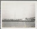
| Date: | 07 25 1960 |
|---|---|
| Description: | Ephraim pier in Eagle Harbor. The pier is made of timbers. A dock and boathouse are on the right. Bare masts rise above the boats. The shoreline and trees ... |
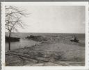
| Date: | 04 16 1963 |
|---|---|
| Description: | Chaudoir Dock in Brussels. The shoreline is on the left and has rocks along its edge. In the background is Lake Michigan. |
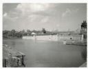
| Date: | 07 02 1960 |
|---|---|
| Description: | View across water towards the Manitowoc Shipbuilding floating drydock. Pilings and grass are in the foreground. On the far shoreline are buildings on a hil... |

| Date: | 06 14 1961 |
|---|---|
| Description: | Aerial view of North and South Harbor Tracts, looking north from South Pier No. 2. There are skyscrapers in the background. there are multiple items of mac... |

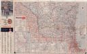
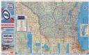
| Date: | 1960 |
|---|---|
| Description: | This colored road map shows roads in Wisconsin as well as portions of nearby states. Information on the quality and type of any road shown can be found in ... |

| Date: | 1962 |
|---|---|
| Description: | This colored road map shows roads in Wisconsin as well as portions of nearby states. The map is organized such that a single map of Wisconsin is divided on... |
| Date: | 1962 |
|---|---|
| Description: | This colored road map shows roads in Wisconsin as well as portions of nearby states. The map is organized such that a single map of Wisconsin is divided on... |

| Date: | 1963 |
|---|---|
| Description: | This colored road map shows automobile roads in Wisconsin as well as portions of nearby states. The map is organized such that a single map of Wisconsin is... |
| Date: | 1963 |
|---|---|
| Description: | This colored road map shows automobile roads in Wisconsin as well as portions of nearby states. The map is organized such that a single map of Wisconsin is... |

| Date: | 1965 |
|---|---|
| Description: | This colored road map shows automobile roads in Wisconsin as well as portions of nearby states. Information on the quality and type of any road shown (inte... |

| Date: | 1966 |
|---|---|
| Description: | This colored road map shows automobile roads in Wisconsin as well as portions of nearby states. Information on the quality and type of any road shown (inte... |

| Date: | 1967 |
|---|---|
| Description: | View from behind of two men sitting on a park bench who are looking at the lake steamer docked in the harbor. In the distance, a red lighthouse is at the e... |
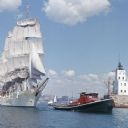
| Date: | 1964 |
|---|---|
| Description: | View across water towards the tugboat "Indiana" pulling the full-rigged, three-masted Norwegian ship "Christian Radich" into port. The sails and hull of th... |
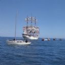
| Date: | 1964 |
|---|---|
| Description: | Nine boats are on the waters of Lake Michigan as they observe the "Christian Radich" sailing. The ship is a full-rigged, three-masted Norwegian ship. The s... |
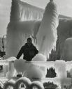
| Date: | 01 1969 |
|---|---|
| Description: | Spray from the lake has built up as thick ice on a ship, creating interesting shapes. A man is standing on the deck. |
If you didn't find the material you searched for, our Library Reference Staff can help.
Call our reference desk at 608-264-6535 or email us at: