 Filter: Categories of Wisconsin Historical Images
Filter: Subject of Great Lakes
Filter: Year of 1800-1899
Filter: Year of 1850-1859
Filter: Categories of Wisconsin Historical Images
Filter: Subject of Great Lakes
Filter: Year of 1800-1899
Filter: Year of 1850-1859

| Date: | 1850 |
|---|---|
| Description: | Pic Island on the north shore of Lake Superior. |
| Date: | 1859 |
|---|---|
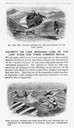
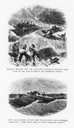
| Description: | A page from Frank Leslie's Illustrated Newspaper with two sketches and a narrative of the sinking of the sidewheeler passenger, Lady Elgin, i... |
| Date: | 1859 |
|---|---|
| Description: | A page of Frank Leslie's Illustrated Newspaper detailing the sinking of the sidewheel passenger, Lady Elgin, in 1860. One sketch is of Edward... |

| Date: | 1857 |
|---|---|
| Description: | Information depicting the history, condition and prospects of the Indian tribes of the United States: collected and prepared under the direction of the Bur... |

| Date: | 1850 |
|---|---|
| Description: | [... through northern United States from New York to Minnesota]. Lithography by T. Sinclair. From Perrault papers, Lucien S. Hanks, donor. |

| Date: | 1853 |
|---|---|
| Description: | Shows railroads, planned and in place. |

| Date: | 1855 |
|---|---|
| Description: | Map reads "Our Country" which is accompanied by a sailor with a flag to the left and workers rejoicing under the Constitution and Laws to the right. Across... |

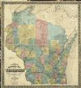
| Date: | 1854 |
|---|---|
| Description: | Map reads, "Map of Wisconsin". The map includes the counties, an inset of the city of Milwaukee, total population of each county and of the state. The scal... |

| Date: | 1856 |
|---|---|
| Description: | A Wisconsin map showing the Wisconsin Superior and St. Croix Railroad. |
| Date: | 1859 |
|---|---|
| Description: | 1859 sectional map of the state of Wisconsin. |

| Date: | 1855 |
|---|---|
| Description: | Drawn around 1855, this map shows the placement of railroad tracks in southern Wisconsin and northern Illinois connecting Milwaukee, Prairie du Chien, Gale... |

| Date: | 1851 |
|---|---|
| Description: | Map exhaustively marks the townships, County Towns and villages of Wisconsin. It also shows rivers, canals, railroads, and plank roads. Each county's popul... |

| Date: | 1852 |
|---|---|
| Description: | Map shows Wisconsin counties by color and includes rivers, lakes and some cities. This information is also given for eastern Minnesota and northern Illinoi... |

| Date: | 1853 |
|---|---|
| Description: | Wisconsin counties by color and shows railroads, common roads, canals, the state capital, county towns, townships, villages, and post offices, |

| Date: | 1854 |
|---|---|
| Description: | Map of the whole state Wisconsin includes an inset of the vicinity of Milwaukee, which shows the boundaries for Lisbon, Menomonee, Pewaukee, Brookfield, Wa... |

| Date: | 1856 |
|---|---|
| Description: | This map shows the entire state of Wisconsin with counties, cities and rivers. It includes an inset of the layout of the streets of Milwaukee and a chart w... |

| Date: | 1857 |
|---|---|
| Description: | This detailed map was drawn nearly a decade after Wisconsin entered statehood. It depicts the entire state, northern Illinois and part of the upper peninsu... |

| Date: | 1855 |
|---|---|
| Description: | Drawn seven years after Wisconsin entered statehood, this map shows the counties, cities, towns, rivers and lakes in the entire state. The map includes a c... |

| Date: | 1858 |
|---|---|
| Description: | Drawn a decade after Wisconsin entered statehood, this 1858 map depicts counties, creeks, rivers, lakes, railroads completed, railroads in progress and com... |

| Date: | 1855 |
|---|---|
| Description: | This map depicts counties, creeks, rivers, lakes, railroads completed, railroads in progress, common roads and the Menomonee Reservation. |
If you didn't find the material you searched for, our Library Reference Staff can help.
Call our reference desk at 608-264-6535 or email us at: