Filter: Categories of Wisconsin Historical Images
Filter: Subject of Great Lakes
Filter: Year of 1800-1899
Filter: Subject of political science
Filter: Categories of Wisconsin Historical Images
Filter: Subject of Great Lakes
Filter: Year of 1800-1899
Filter: Subject of political science

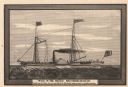
| Date: | 1862 |
|---|---|
| Description: | Lithography of C. Van Benthuysen. |

| Date: | 1835 |
|---|---|
| Description: | Map reads: "Map of the United States of America with its Territories and Districts - Including also a part of Upper and Lower Canada and Mexico". The map i... |

| Date: | 1855 |
|---|---|
| Description: | Map reads "Our Country" which is accompanied by a sailor with a flag to the left and workers rejoicing under the Constitution and Laws to the right. Across... |

| Date: | 1895 |
|---|---|
| Description: | Drawing of the steamboat Western World. Several people stand on the deck. An American flag and flags reading Detroit, Michigan Central, Buffalo, N.Y... |

| Date: | 1883 |
|---|---|
| Description: | A hand-colored map of Wisconsin showing the nine congressional districts, it also shows the counties, cities, railroads, rivers, and lakes in the state. |

| Date: | 1845 |
|---|---|
| Description: | Wisconsin was considered part of Michigan Territory until 1836, a year before Michigan entered statehood. Drawn three years before Wisconsin entered stateh... |
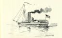
| Date: | 03 1882 |
|---|---|
| Description: | Engraving after a drawing of the steamer Walk-in-the-Water, the first steamboat to sail the Great Lakes. |
If you didn't find the material you searched for, our Library Reference Staff can help.
Call our reference desk at 608-264-6535 or email us at: