 Filter: Categories of Wisconsin Historical Images
Filter: Subject of Great Lakes
Filter: Year of 1800-1899
Filter: Subject of cities and towns
Filter: Categories of Wisconsin Historical Images
Filter: Subject of Great Lakes
Filter: Year of 1800-1899
Filter: Subject of cities and towns

| Date: | 1878 |
|---|---|
| Description: | Map reads: "The P.P. Mast & Co's New Map of Wisconsin, Minnesota, and Northern Iowa". There are various advertisements for P.P. Mast & Co's broad-cast seed... |

| Date: | 1855 |
|---|---|
| Description: | Map reads "Our Country" which is accompanied by a sailor with a flag to the left and workers rejoicing under the Constitution and Laws to the right. Across... |

| Date: | 1854 |
|---|---|
| Description: | Map reads, "Map of Wisconsin". The map includes the counties, an inset of the city of Milwaukee, total population of each county and of the state. The scal... |

| Date: | 1864 |
|---|---|
| Description: | Map reads: "Johnson's Wisconsin and Michigan". There is a decorative border, a scale of which ten miles is approximately one inch and individual counties d... |

| Date: | 1896 |
|---|---|
| Description: | Section 3 of 12, this bicycle road map features Wisconsin bicycle routes in the counties of Winnebago, Calumet, Manitowoc, Outagamie, Brown, Kewaunee, and ... |

| Date: | 1878 |
|---|---|
| Description: | A color map detailing Ashland and Bayfield counties, including Lake Superior and the Apostle Islands. |
| Date: | 1859 |
|---|---|
| Description: | 1859 sectional map of the state of Wisconsin. |

| Date: | 1877 |
|---|---|
| Description: | Map of northern Wisconsin showing the lands owned by Cornell University (shaded portions) in 1877. The map depicts the lakes, river systems, towns, and th... |

| Date: | 1887 |
|---|---|
| Description: | A bird's-eye map of Menekaune, Menominee and Marinette. |

| Date: | 1887 |
|---|---|
| Description: | The bay shore of Menominee filled with driftwood. |

| Date: | 1886 |
|---|---|
| Description: | Wisconsin map showing land offices, railroads completed, railroad land grants and Indian reservations. |

| Date: | 1891 |
|---|---|
| Description: | Color illustration of the grounds and buildings of the 1893 World's Fair or Columbian Exposition. |

| Date: | 1835 |
|---|---|
| Description: | Ink on tracing paper map of Green Bay, Wisconsin and nearby areas, Lake Winnebago, Fox and Wolf Rivers, and the junctions of the Mississippi and Wisconsin ... |

| Date: | 1847 |
|---|---|
| Description: | In 1847, a year before Wisconsin entered statehood, most of the county shapes in southeastern and southern Wisconsin looked the same as they do today, wher... |

| Date: | 1855 |
|---|---|
| Description: | Drawn around 1855, this map shows the placement of railroad tracks in southern Wisconsin and northern Illinois connecting Milwaukee, Prairie du Chien, Gale... |

| Date: | 1851 |
|---|---|
| Description: | Map exhaustively marks the townships, County Towns and villages of Wisconsin. It also shows rivers, canals, railroads, and plank roads. Each county's popul... |

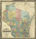
| Date: | 1852 |
|---|---|
| Description: | Map shows Wisconsin counties by color and includes rivers, lakes and some cities. This information is also given for eastern Minnesota and northern Illinoi... |

| Date: | 1853 |
|---|---|
| Description: | Wisconsin counties by color and shows railroads, common roads, canals, the state capital, county towns, townships, villages, and post offices, |

| Date: | 1854 |
|---|---|
| Description: | Map of the whole state Wisconsin includes an inset of the vicinity of Milwaukee, which shows the boundaries for Lisbon, Menomonee, Pewaukee, Brookfield, Wa... |

| Date: | 1856 |
|---|---|
| Description: | This map shows the entire state of Wisconsin with counties, cities and rivers. It includes an inset of the layout of the streets of Milwaukee and a chart w... |
If you didn't find the material you searched for, our Library Reference Staff can help.
Call our reference desk at 608-264-6535 or email us at: