 Filter: Categories of Wisconsin Historical Images
Filter: Subject of Great Lakes
Filter: Subject of water
Filter: Categories of Wisconsin Historical Images
Filter: Subject of Great Lakes
Filter: Subject of water

| Date: | 1858 |
|---|---|
| Description: | This map shows the railroads in southern Wisconsin and their connections with points in Iowa and Illinois. An inset map shows rail connections between sout... |

| Date: | 1911 |
|---|---|
| Description: | This map of Wisconsin, the western portion of Michigan's Upper Peninsula, and northern Illinois shows counties, towns, cities and villages, rivers and lake... |

| Date: | 02 1823 |
|---|---|
| Description: | A map featuring the North American expedition from Pittsburgh to the Rocky Mountains led by Edwin James. |

| Date: | 1904 |
|---|---|
| Description: | A young Aldo Leopold is posing smiling, wearing a jacket and bow tie while sitting on a pier. He is vacationing in the Cheneaux Islands. A shoreline with b... |

| Date: | 1906 |
|---|---|
| Description: | A hand-colored commercial map of Wisconsin and portions of eastern Minnesota, Iowa, northern Illinois, and the Michigan’s Upper Peninsula. The map shows ra... |

| Date: | |
|---|---|
| Description: | An ink, watercolor, and pencil on paper, hand-drawn map that shows the Michigan-Wisconsin boundary in Iron, Vilas, Forest, Florence, and Marinette counties... |

| Date: | 1910 |
|---|---|
| Description: | Chart of Lake Michigan noting soundings near shore and across the lake between harbors. Also included are portions of Wisconsin, Michigan, Illinois, Indian... |

| Date: | 1905 |
|---|---|
| Description: | This early 20th century map identifies the locations of the Divide Resort and Spider Lake Resort in Vilas County, Wisconsin. Also shown are trails, stage l... |

| Date: | 1952 |
|---|---|
| Description: | Map of the barley-growing regions of North America, published by the Rahr Malting Company, Manitowoc, Wisconsin, 1952. |

| Date: | 1938 |
|---|---|
| Description: | This tourist map of Door County, Wisconsin, lists the points of interest and resorts in the area. An inset location map is included. |

| Date: | 1894 |
|---|---|
| Description: | A map of the state of Wisconsin sectioned by county. Scale: eight miles to the inch. |

| Date: | 2013 |
|---|---|
| Description: | Map is the most extensive endeavor to date to accurately locate and document both prehistoric place names and natural features of the Menominee language wi... |

| Date: | 1934 |
|---|---|
| Description: | This map shows industrial points of interest in Superior. The top of the map reads: "Superior, Douglas County, Wisconsin, as this Industrial Tour map indic... |

| Date: | 1951 |
|---|---|
| Description: | This map shows Ashland and Washburn harbors in shades of blue and yellow. Water depths shown by isolines and soundings, and relief is shown by contours. Th... |

| Date: | 1785 |
|---|---|
| Description: | Map of part of North America engraved and hand-colored (the light brown design is a superposition of the map and cartouche derived from the oxidation of th... |

| Date: | 1893 |
|---|---|
| Description: | Map of Wisconsin showing Michigan's upper peninsula, the northern portion of Illinois and part of eastern Minnesota. There is an inset map of Isle Royale i... |

| Date: | 02 01 1793 |
|---|---|
| Description: | Text in the upper right corner reads, "A Map of The Western Part of the Territories belonging to the United States of America. Drawn from the best authorit... |
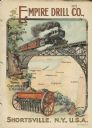
| Date: | 1901 |
|---|---|
| Description: | Catalog cover with the title: "The Three Greatest Empires," features an illustration of an Empire Drill in the foreground, and in the background a train tr... |

| Date: | |
|---|---|
| Description: | Three women stand on the shore in front of the steamer Barker at Devils Island natural dock. |

| Date: | 1868 |
|---|---|
| Description: | This map is one of the earliest weather maps of the United States, which traced an 1859 storm across the continent. Manuscript annotations in red ink show ... |
If you didn't find the material you searched for, our Library Reference Staff can help.
Call our reference desk at 608-264-6535 or email us at: