 Filter: Categories of Wisconsin Historical Images
Filter: Subject of Great Lakes
Filter: Subject of transportation
Filter: Categories of Wisconsin Historical Images
Filter: Subject of Great Lakes
Filter: Subject of transportation
| Date: | |
|---|---|
| Description: | Carte-de-visite map of Wisconsin. Broken down into a grid, and includes some topography and Lake Michigan. The letters "M.C." have been written on top of t... |

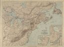
| Date: | 1835 |
|---|---|
| Description: | Map reads: "Map of the United States of America with its Territories and Districts - Including also a part of Upper and Lower Canada and Mexico". The map i... |

| Date: | 1878 |
|---|---|
| Description: | Map reads: "The P.P. Mast & Co's New Map of Wisconsin, Minnesota, and Northern Iowa". There are various advertisements for P.P. Mast & Co's broad-cast seed... |

| Date: | |
|---|---|
| Description: | Map reads: "The United States from the Latest Authorities". View of the states and territories. |

| Date: | 1855 |
|---|---|
| Description: | Map reads "Our Country" which is accompanied by a sailor with a flag to the left and workers rejoicing under the Constitution and Laws to the right. Across... |

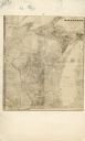
| Date: | 1854 |
|---|---|
| Description: | Map reads, "Map of Wisconsin". The map includes the counties, an inset of the city of Milwaukee, total population of each county and of the state. The scal... |

| Date: | 1864 |
|---|---|
| Description: | Map reads: "Johnson's Wisconsin and Michigan". There is a decorative border, a scale of which ten miles is approximately one inch and individual counties d... |
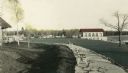
| Date: | |
|---|---|
| Description: | Hand-colored view of the Thordarson estate including the boathouse and a stone-paved path with benches. |
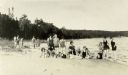
| Date: | 09 07 1927 |
|---|---|
| Description: | Women employees of Thordarson? in bathing suits on the beach during the First Girls Party to Rock Island. |
| Date: | |
|---|---|
| Description: | The stairs and dock at the lighthouse on Rock Island. |

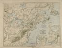
| Date: | 1784 |
|---|---|
| Description: | Map of The United States of America according to the Treaty of Peace of 1784. |
| Date: | 1610 |
|---|---|
| Description: | A map of New France, including parts of the United States and Canada, to illustrate the Jesuit relations and allied documents. There is some handwriting an... |
| Date: | 1610 |
|---|---|
| Description: | A map of New France, including parts of the United States and Canada, to illustrate the Jesuit relations and allied documents. |

| Date: | 1937 |
|---|---|
| Description: | Official state highway map, with insets of cities. |

| Date: | 1970 |
|---|---|
| Description: | Aerial view of International Harvester's Wisconsin Steel Works, with a river and Lake Michigan in the background. |

| Date: | |
|---|---|
| Description: | View from shoreline of boats docked at the fishing wharf. People are fishing from the pier, and a group of people are in a rowboat near a ferry. There are ... |
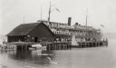
| Date: | |
|---|---|
| Description: | View across water towards a large ferry docked at the fishing wharf. A large group of people are standing on the pier, and passengers are standing at the r... |
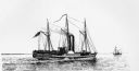
| Date: | 1895 |
|---|---|
| Description: | Drawing of the lake steamer, Michigan with another vessel in the background. |

| Date: | 1895 |
|---|---|
| Description: | Drawing of the steamboat Western World. Several people stand on the deck. An American flag and flags reading Detroit, Michigan Central, Buffalo, N.Y... |
If you didn't find the material you searched for, our Library Reference Staff can help.
Call our reference desk at 608-264-6535 or email us at:
