 Filter: Categories of Wisconsin Historical Images
Filter: Subject of Great Lakes
Filter: Subject of michigan, lake
Filter: Categories of Wisconsin Historical Images
Filter: Subject of Great Lakes
Filter: Subject of michigan, lake

| Date: | 1936 |
|---|---|
| Description: | This colored road map shows automobile roads in Wisconsin as well as portions of nearby states. Information on the quality and type of any given road (pave... |

| Date: | |
|---|---|
| Description: | This colored road map shows automobile roads in Wisconsin as well as portions of nearby states. Information on the quality and type of any road shown (pave... |

| Date: | 1967 |
|---|---|
| Description: | View from behind of two men sitting on a park bench who are looking at the lake steamer docked in the harbor. In the distance, a red lighthouse is at the e... |
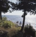
| Date: | |
|---|---|
| Description: | View down slope towards a family walking along the shore of Lake Michigan at Gordon Lodge. |
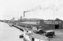
| Date: | 07 1936 |
|---|---|
| Description: | Elevated view of fishing tugs moored alongside the wharf at Marinette. Two automobiles are parked in the foreground, just in front of the Bridge Fish Co. b... |
| Date: | 07 1936 |
|---|---|
| Description: | Elevated view of seagulls flying over fishing tugs moored at the wharf in Algoma. Small warehouse buildings line the wharf. Fish net drying reels are visib... |

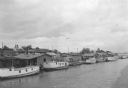
| Date: | 1935 |
|---|---|
| Description: | View from shoreline towards fishing boats of various sizes, and sailboats docked at the wharf at Fish Creek. Two persons are carrying gear toward the pier.... |
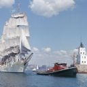
| Date: | 1964 |
|---|---|
| Description: | View across water towards the tugboat "Indiana" pulling the full-rigged, three-masted Norwegian ship "Christian Radich" into port. The sails and hull of th... |
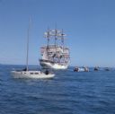
| Date: | 1964 |
|---|---|
| Description: | Nine boats are on the waters of Lake Michigan as they observe the "Christian Radich" sailing. The ship is a full-rigged, three-masted Norwegian ship. The s... |

| Date: | 1846 |
|---|---|
| Description: | Chart of Green Bay showing depths and locations of numerous islands at a scale of 1 inch to 2 miles. There is also a profile of the dividing ridge at Sturg... |

| Date: | 08 2007 |
|---|---|
| Description: | View of the bottom, or bilge, of the Appomattox. The bilge was made entirely of wood, as on shipbuilder James Davidson’s other steamers. The heavy k... |

| Date: | 08 2007 |
|---|---|
| Description: | An archaeologist investigates floor keelsons near the bow of the Appomattox. |

| Date: | 08 2007 |
|---|---|
| Description: | View of steel plating lining the central keelson on the wreckage of the Appomattox. |

| Date: | 08 2003 |
|---|---|
| Description: | View of the gear and shaft of the Kate Kelly at the bottom of Lake Michigan. |

| Date: | 08 2003 |
|---|---|
| Description: | View of the remains of the hull of the Kate Kelly at the bottom of Lake Michigan. |

| Date: | 08 2003 |
|---|---|
| Description: | View of the mast step which rested on the main keelson and held the bottom of one of the Kate Kelly’s tall masts. |

| Date: | 08 2003 |
|---|---|
| Description: | View of the remains of the rigging of the Kate Kelly at the bottom of Lake Michigan. |

| Date: | |
|---|---|
| Description: | View of the remains of the centerboard trunk of the Lumberman at the bottom of Lake Michigan. |

| Date: | |
|---|---|
| Description: | Archaeologists examining the wreckage of the Lumberman at the bottom of Lake Michigan. |

| Date: | |
|---|---|
| Description: | View of the lumber ports of the wrecked Lumberman at the bottom of Lake Michigan. |
If you didn't find the material you searched for, our Library Reference Staff can help.
Call our reference desk at 608-264-6535 or email us at: