 Filter: Categories of Wisconsin Historical Images
Filter: Subject of Great Lakes
Filter: Subject of human settlements
Filter: Categories of Wisconsin Historical Images
Filter: Subject of Great Lakes
Filter: Subject of human settlements

| Date: | 1923 |
|---|---|
| Description: | This map includes an explanation that reads: "This chart shows the movement of rye on the Great Lakes, St. Lawrence River, and New York State Barge Canal d... |

| Date: | 1923 |
|---|---|
| Description: | This map shows portions of Minnesota, Iowa, Wisconsin, Illinois, Indiana, Ohio, Michigan, New York, Vermont, Massachusetts, Connecticut, Ontario, and Quebe... |

| Date: | 10 15 1956 |
|---|---|
| Description: | This map shows cities with improved harbors along the Great Lakes. A portion of Illinois, Michigan, Ohio, Ontario, and Quebec are also shown. A legend and... |

| Date: | 07 01 1875 |
|---|---|
| Description: | This map shows Lake Ontario, and a portion of Lake Erie and Oneida Lake. Towns surrounding these lakes in Canada and New York are labeled. A key to former ... |

| Date: | 07 01 1876 |
|---|---|
| Description: | This map shows Lake Ontario, and a portion of Lake Erie and Oneida Lake. Towns surrounding these lakes in Canada and New York are labeled. A key to former ... |

| Date: | 07 01 1876 |
|---|---|
| Description: | This map shows towns, railroads, and rivers in Ohio, Michigan, Pennsylvania, New York, and Ontario that surround Lake Erie. A key to completed and uncomple... |
| Date: | 1923 |
|---|---|
| Description: | This map shows the movement of anthracite coal throughout Minnesota, Wisconsin, Ontario, Quebec, Michigan, Illinois, Indiana, and New York. Iowa, Vermont,... |

| Date: | 1905 |
|---|---|
| Description: | This map shows railroads, towns, lights, lights to be established, fog signals, light-vessels, lighted buoys, light-house depots, and light-house reservati... |

| Date: | 1908 |
|---|---|
| Description: | This map shows railroads, towns, lights, lights to be established, fog signals, light-vessels, lighted buoys, light-house depots, and light-house reservati... |

| Date: | 1846 |
|---|---|
| Description: | This map shows rivers, lakes, and towns in states west of the Mississippi River. Lake Michigan, Lake Superior, and Green Bay are labeled. Some areas are ou... |
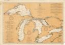
| Date: | 08 30 1911 |
|---|---|
| Description: | Chart showing all of the Great Lakes: Lake Superior, Lake Michigan, Lake Huron, Lake Erie, and Lake Ontario and canals, rivers and cities that border the l... |

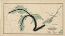
| Date: | 1923 |
|---|---|
| Description: | This map includes an explanation that reads: "This chart shows the movement of wheat on the Great Lakes, St. Lawrence River, and New York State Barge Canal... |

| Date: | 2003 |
|---|---|
| Description: | The front of map shows trails throughout the bottom half of Wisconsin and includes text on snowmobile rules and tourism contacts. The reverse shows trails ... |
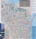
| Date: | 2007 |
|---|---|
| Description: | The front of map shows trails throughout the bottom half of Wisconsin and includes text on snowmobile rules and tourism contacts. The reverse shows trails ... |

| Date: | 1975 |
|---|---|
| Description: | This map provides an index of outdated quadrangle maps for the state. Communities, counties, rivers, and lakes are labeled including Lake Michigan and Lake... |

| Date: | 1851 |
|---|---|
| Description: | This map shows townships, villages, Indian villages, railroads, roads, mills, prairies, swamps, and canals. An inset map shows a plat of the copper distric... |

| Date: | 1936 |
|---|---|
| Description: | This map shows the state trunk highway system and county trunk highways. This map show surface type on state and county trunk highways and the locations of... |

| Date: | 1858 |
|---|---|
| Description: | This map shows the proposed railways of the Tomah & Lake St. Croix Railroad (from Tomah to Hudson) and the St. Croix & Lake Superior Railroad (from Hudson ... |

| Date: | 1936 |
|---|---|
| Description: | This map shows road surfaces, construction, flying fields, seaplane landings, populations of cities and towns, and ferry routes of Wisconsin and some of th... |

| Date: | 1937 |
|---|---|
| Description: | This map shows the major roads, cities, towns, lakes, and rivers of Wisconsin and some of the neighboring states. The front includes an add for Coca-Cola, ... |
If you didn't find the material you searched for, our Library Reference Staff can help.
Call our reference desk at 608-264-6535 or email us at: