Filter: Categories of Wisconsin Historical Images
Filter: Subject of Great Lakes
Filter: Creator Name of Unknown
Filter: Categories of Wisconsin Historical Images
Filter: Subject of Great Lakes
Filter: Creator Name of Unknown

| Date: | |
|---|---|
| Description: | Aerial view of harbor, with shipyards in the foreground and Superior in the background. Caption reads: "Aerial View of Harbor, Superior, Wisconsin." |

| Date: | |
|---|---|
| Description: | Aerial view of Marinette Harbor looking out towards Lake Superior. A lighthouse and breakwater extend out into the lake. Industrial buildings, cranes, and ... |

| Date: | 1902 |
|---|---|
| Description: | This map includes six diagrams of the Great Lakes Region comparing advantages of geographical positions and strategic considerations. Portions of Iowa, Ill... |

| Date: | 1905 |
|---|---|
| Description: | This map shows railroads, towns, lights, lights to be established, fog signals, light-vessels, lighted buoys, light-house depots, and light-house reservati... |

| Date: | 1905 |
|---|---|
| Description: | This map shows railroads, towns, lights, lights to be established, fog signals, light-vessels, lighted buoys, light-house depots, and light-house reservati... |

| Date: | 10 15 1956 |
|---|---|
| Description: | This map shows cities with improved harbors along the Great Lakes. A portion of Illinois, Michigan, Ohio, Ontario, and Quebec are also shown. A legend and... |

| Date: | 07 01 1876 |
|---|---|
| Description: | This map shows Lake Ontario, and a portion of Lake Erie and Oneida Lake. Towns surrounding these lakes in Canada and New York are labeled. A key to former ... |

| Date: | 07 01 1876 |
|---|---|
| Description: | This map shows towns, railroads, and rivers in Ohio, Michigan, Pennsylvania, New York, and Ontario that surround Lake Erie. A key to completed and uncomple... |

| Date: | 1905 |
|---|---|
| Description: | This map shows railroads, towns, lights, lights to be established, fog signals, light-vessels, lighted buoys, light-house depots, and light-house reservati... |

| Date: | 1908 |
|---|---|
| Description: | This map shows railroads, towns, lights, lights to be established, fog signals, light-vessels, lighted buoys, light-house depots, and light-house reservati... |
| Date: | 1910 |
|---|---|
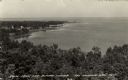
| Description: | View along shoreline of Weborg Point before the area became Peninsula State Park. Green Bay is on the left. Two wood buildings are along the shoreline in t... |
| Date: | 11 29 1908 |
|---|---|
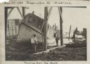
| Description: | Men working on pulling the boat "Fish Hawk" out of the water. One man is kneeling in front of the boat and looking at the camera. A man in the background i... |

| Date: | 1755 |
|---|---|
| Description: | Map of the Great Lakes region during the French and Indian War. It shows in great detail the territories, borders and boundary lines, Native American tribe... |
| Date: | |
|---|---|
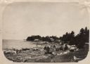
| Description: | Elevated view of Green Bay from the Alpine Tower at Egg Harbor. A few dwellings are along the shoreline on the left. Caption reads: "View from the Alpine T... |

| Date: | |
|---|---|
| Description: | Drawing of a map showing the cruise routes from Eagle Inn Dock and the points of interest. There is a schedule and rates on the reverse. |

| Date: | |
|---|---|
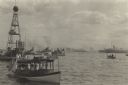
| Description: | View across water towards the "Carolina" steamer docked at Ephraim. Many people are standing on the pier. Caption reads: "Ephraim-Wis." |

| Date: | |
|---|---|
| Description: | View across water towards a cargo ship at dock in front of large grain elevators. |

| Date: | 1935 |
|---|---|
| Description: | Polygonic projection map of the lower part of Lake Michigan, surrounded by the states of Wisconsin, Illinois, Indiana, Michigan. Includes handwritten text ... |

| Date: | |
|---|---|
| Description: | In 1935, 202 families from the northern regions of Michigan, Wisconsin, and Minnesota were selected for this resettlement project, located near Palmer, Ala... |
If you didn't find the material you searched for, our Library Reference Staff can help.
Call our reference desk at 608-264-6535 or email us at: