 Filter: Categories of Wisconsin Historical Images
Filter: Subject of Grain elevators
Filter: Subject of industries
Filter: Subject of streets
Filter: Categories of Wisconsin Historical Images
Filter: Subject of Grain elevators
Filter: Subject of industries
Filter: Subject of streets
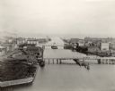
| Date: | 1898 |
|---|---|
| Description: | Bird's-eye view of the Manitowoc Harbor facing east from Northern Grain Company's Elevator B. In the foreground, Mathews & Keith's pile driver scow is secu... |

| Date: | 1900 |
|---|---|
| Description: | A Sanborn fire insurance map of Sauk City created in 1900. |
If you didn't find the material you searched for, our Library Reference Staff can help.
Call our reference desk at 608-264-6535 or email us at:

