 Filter: Categories of Wisconsin Historical Images
Filter: Subject of Gasoline industry
Filter: Subject of human settlements
Filter: Categories of Wisconsin Historical Images
Filter: Subject of Gasoline industry
Filter: Subject of human settlements
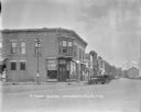
| Date: | 1926 |
|---|---|
| Description: | View across street of the Farmers Merchants Bank on a corner. On the right are parked cars along the curb in front of "Onsgard Bros." which has a Red Crown... |

| Date: | 1927 |
|---|---|
| Description: | View of intersection towards a restaurant and grocery on the left, with dwellings and other buildings in the background. A group of people standing posing ... |

| Date: | 1938 |
|---|---|
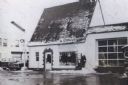
| Description: | A Texaco Super Service filling station owned by H.F. Bartsch on the corner of Park and Midland Streets. A home is on the opposite side of Midland Street. T... |

| Date: | 1920 |
|---|---|
| Description: | View down center of unpaved street, showing storefronts on the right, with a metal railing between the street and sidewalk. There is a gas pump at the rail... |

| Date: | 1909 |
|---|---|
| Description: | Colorized photographic postcard of the Gas Company's building along the river in Eau Claire. Caption reads: "Gas Co's Building, Eau Claire, Wis." |

| Date: | 1930 |
|---|---|
| Description: | This map shows city wards, streets, railroads, parks, Lake Butte Des Morts, Lake Winnebago, advertisements for Dixie Oils Gasoline, a list of Cook & Brown ... |
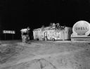
| Date: | 1956 |
|---|---|
| Description: | Night view of a Shell service station with Christmas decorations. There are tree branch swags on the building and on the poles and light fixture around the... |

| Date: | 1943 |
|---|---|
| Description: | This map shows roads, trails, taverns, schools, golf, gas stations, campsites, resorts, and towers. The lower left of the map includes a legend. The map co... |
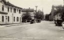
| Date: | |
|---|---|
| Description: | View looking up Columbia Avenue, with the Merchants Bank on the left, and a mill, and a church further down on the right. Automobiles are parked along the ... |

| Date: | 1927 |
|---|---|
| Description: | This map details automobile routes throughout the state as well as parts of Iowa, Minnesota, Michigan and Illinois. Cities, the Mississippi River, Lake Mic... |

| Date: | 1925 |
|---|---|
| Description: | The map shows the entire state with portions of Illinois, Iowa, Minnesota, and Michigan. The map shows concrete, gravel, all weather earth, clay, and sand ... |
| Date: | 1966 |
|---|---|
| Description: | Service station located at 601 West Washington Avenue, on the intersection with South Bedford Street. This is the view from South Bedford Street. In the ba... |
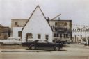
| Date: | 1966 |
|---|---|
| Description: | Service station located at 601 West Washington Avenue, on the intersection with South Bedford Street. This is the view from West Washington Avenue, and sno... |

| Date: | 1932 |
|---|---|
| Description: | This map shows automobile routes across Wisconsin and parts of Illinois, Michigan, Minnesota and Iowa. The Mississippi River, Lake Michigan, Lake Superior,... |
| Date: | 1957 |
|---|---|
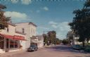
| Description: | Color print of a view of Main Street. The Red Owl Agency is on the left, and a Standard Service Station is further down the street on the right. Cars are p... |

| Date: | 1935 |
|---|---|
| Description: | This road map shows automobile routes across the state of Wisconsin. Advertisements for various hotels are featured along the bottom edge of the map, while... |

| Date: | |
|---|---|
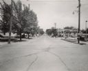
| Description: | View down center of a city street, which is lined with bars, restaurants and other businesses. Automobiles are parked at an angle at the curbs. Caption rea... |
| Date: | 08 29 1941 |
|---|---|
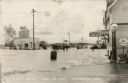
| Description: | View of a flooded road with a truck and cars making their way through. Men are standing knee-deep in the water. A Standard Oil Station is on the left. Ther... |
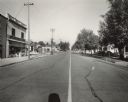
| Date: | 1952 |
|---|---|
| Description: | View of Washington Street from the intersection of South 19th Street, facing east. On the right, a sign identifies the corner location of the Tankar Gas St... |
| Date: | 1952 |
|---|---|
| Description: | View of Washington Street from South 18th Street, facing west. Signage identifies the two-story structure on the left as Dunning's Clover Farm Store. Patt... |
If you didn't find the material you searched for, our Library Reference Staff can help.
Call our reference desk at 608-264-6535 or email us at: