 Filter: Categories of Wisconsin Historical Images
Filter: Subject of Furs
Filter: Subject of rivers
Filter: Categories of Wisconsin Historical Images
Filter: Subject of Furs
Filter: Subject of rivers
| Date: | |
|---|---|
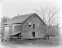
| Description: | Two girls and a boy posed by a tree in front of a two-story wooden building, probably the John Edmunds' Charter Oak grist mill built on Squaw Creek in 1866... |
| Date: | |
|---|---|
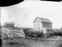
| Description: | Woman and girl posed sitting under a fur in a carriage pulled by a single horse by a wooden bridge. Behind them is a large wooden building, possibly a mill... |
| Date: | 04 1922 |
|---|---|
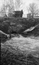
| Description: | The photographer's wife Clothilde leans on a railing, looking at water rushing through a stone culvert on Fish Creek. Their car is parked on the roadway. A... |

| Date: | 1740 |
|---|---|
| Description: | Map including the regions and cities of the northern half of North America. Native American land, rivers, lakes, mountains are labeled. Mountains, marshes,... |

| Date: | 1673 |
|---|---|
| Description: | Decorative map of the southeastern region of North America, from the York River in Virginia to northern Florida. The coat of arms of France and England mar... |

| Date: | 1667 |
|---|---|
| Description: | Map of Virginia depicting the discoveries detailed by John Smith in his exploration of the region. It shows Jamestown, Native American tribes and villages,... |
If you didn't find the material you searched for, our Library Reference Staff can help.
Call our reference desk at 608-264-6535 or email us at: