 Filter: Categories of Wisconsin Historical Images
Filter: Subject of Fortification
Filter: Subject of water
Filter: Categories of Wisconsin Historical Images
Filter: Subject of Fortification
Filter: Subject of water

| Date: | 11 1781 |
|---|---|
| Description: | Map of New York, Staten Island, and Long Island, showing the placements of forts, and the movement of troops in 1776. The map also includes towns, cities, ... |

| Date: | 1776 |
|---|---|
| Description: | Fairly detailed map of New York City and parts of Long Island. It shows streets, roads, wharves, ferries, ship yards, Fort George and the battery, public b... |

| Date: | 04 1777 |
|---|---|
| Description: | Map showing the area from Newtown, Pennsylvania to Kingston, New Jersey, with routes and battles of British (red) and American forces (blue). The map inclu... |

| Date: | 1781 |
|---|---|
| Description: | Map of the southern portion of the Chesapeake Bay and surrounding lands. It shows counties, a few cities and towns, forts, roads, islands, topographical fe... |

| Date: | 1791 |
|---|---|
| Description: | Small map of an abandoned Native American town and fort at the junction of the Ohio and Muskingum River. It shows the fortifications, an outline of the tow... |
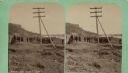
| Date: | 04 18 1888 |
|---|---|
| Description: | Stereograph of fireplace ruins on the site of an old French fort, possibly built by Nicholas Perrot. There is an electric pole behind the fireplace and a g... |

| Date: | 1915 |
|---|---|
| Description: | Soldiers fortifying an embankment on the southwest battlefront in South Tyrol. |

| Date: | |
|---|---|
| Description: | Fortifying an embankment on the southwest battlefront. |

| Date: | 1914 |
|---|---|
| Description: | Searchlight positioned on a fort in Antwerp in order to light a section of railroad track. Water is in the foreground. |

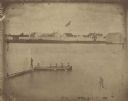
| Date: | 1851 |
|---|---|
| Description: | Elevated view across water towards Fort Howard. In the foreground is a man standing on a pier, and in the water nearby are five men rowing in a boat. Capti... |

| Date: | |
|---|---|
| Description: | Keeping a close watch on the Gardasee (Lake Garda). There are obstacles on the water make to make it impossible to climb over the embankment. |

| Date: | |
|---|---|
| Description: | Soldiers are fortifying the banks of a river with barbed wire. |

| Date: | |
|---|---|
| Description: | Concrete machinegun nest on the Molvenosee (Lake Molveno). |

| Date: | 1814 |
|---|---|
| Description: | A map of the Harbour (sic) of St. Catherine (Brazil). |
| Date: | 1851 |
|---|---|
| Description: | A rare photograph of U.S. Army soldiers stationed at Fort Howard rowing a boat on the Fox River. Fort Howard, built in 1816, was the first in the chain of ... |

| Date: | 05 08 1927 |
|---|---|
| Description: | Two men are standing by a sign, near a fence, marking the former location of Fort Antoine. |

| Date: | 1818 |
|---|---|
| Description: | Overhead view of the layout of the fort, with the Fox River at the top, and a "Cranberry Marsh of 1/2 mile in extent" below right. At the bottom is a rende... |
| Date: | |
|---|---|
| Description: | Elevated view of Fort Crawford facing west showing north row of buildings. The Mississippi River is in the background. Typewritten caption reads: "Fort Cra... |
If you didn't find the material you searched for, our Library Reference Staff can help.
Call our reference desk at 608-264-6535 or email us at:
