 Filter: Categories of Wisconsin Historical Images
Filter: Subject of Fortification
Filter: Subject of mountains
Filter: Categories of Wisconsin Historical Images
Filter: Subject of Fortification
Filter: Subject of mountains
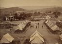
| Date: | 1864 |
|---|---|
| Description: | Elevated view of Battery C, 1st Regiment, Wisconsin Heavy Artillery at Fort Sherman, shown here after the battles of Missionary Ridge and Lookout Mountain.... |

| Date: | 1832 |
|---|---|
| Description: | Fort Union, on the Missouri River in Montana. |

| Date: | 1832 |
|---|---|
| Description: | Fort Clark, on the Missouri River, February 1834. |
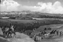
| Date: | |
|---|---|
| Description: | An illustrated view of Fort Union (on the North Dakota-Montana boundary), with an Indian encampment. |

| Date: | |
|---|---|
| Description: | Elevated view of Fort Seward from Mount Rippinsky, showing Pyramid Harbor and Davidson Glacier in distance. Caption reads: "Haines and Fort Wm. H. Seward f... |
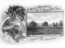
| Date: | |
|---|---|
| Description: | A Christmas Card with two views. The on on the left is featuring an image of a girl sledding while wearing winter gear, and on the right is a photograph of... |
| Date: | 1866 |
|---|---|
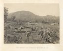
| Description: | A fence or battlement, with battered trees overlooking a valley. Kenesaw Mountain is in the distance. |
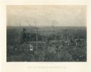
| Date: | 1866 |
|---|---|
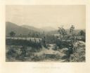
| Description: | Earthworks in a field in foreground. In the middle distance is a small house with a fence. The Kenesaw Mountain is in the background. |
| Date: | 1866 |
|---|---|
| Description: | Two men stand on either side of an opening in the earthworks at Allatoona Pass. Mountains are in the distance. Plate 28 |
| Date: | 1866 |
|---|---|
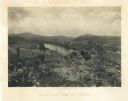
| Description: | View towards the Allatoona Pass from behind earthworks overlooking the Etawah River. A railroad bridge crosses the river on the right. Plate 24 |

| Date: | 1866 |
|---|---|
| Description: | View along earthworks overlooking the Etawah River and a railroad bridge. A tree stripped of branches and bark is on the left. Plate 23 |

| Date: | 1864 |
|---|---|
| Description: | View down to valley of Union soldiers posing on the roof of a log building. A log bridge crosses a stream, and many trees are on the hillsides. Plate 05... |

| Date: | 1719 |
|---|---|
| Description: | This extremely detailed and ornate map shows the cities, Native American land, mountains, lakes, rivers, and European claims of North America. An inset map... |

| Date: | 1755 |
|---|---|
| Description: | Large format map of America and Canada east of the Mississippi River. D'Anville marks the locations of rivers, lakes, settlements, cities, Native American ... |

| Date: | 1780 |
|---|---|
| Description: | Map of North America from Lake Ontario through the Great Plains, and James Bay to Illinois. It shows rivers, lakes, and mountains in great detail, and labe... |

| Date: | 1780 |
|---|---|
| Description: | Map of North America east of Mexico showing colonial boundaries, forts, cities, Native American land, mountains, waterfalls, lakes, and rivers. Short notes... |

| Date: | 1770 |
|---|---|
| Description: | Map of North America showing the boundaries between French, Spanish, and English claims after the French and Indian War. Kitchin includes numerous place na... |

| Date: | 1778 |
|---|---|
| Description: | Map of the land between Fort Ticonderoga and Albany. It shows cities, forts, mills, roads, mountains, swamps, waterfalls, lakes, and rivers. A few annotati... |

| Date: | 10 1776 |
|---|---|
| Description: | Broadside map showing the British invasion of New York city in August and September of 1776. The map shows important cities, forts, roads, hills, mountains... |

| Date: | |
|---|---|
| Description: | A man is sitting on a horse in front of the cast and crew of the film "The Adventures of Marco Polo." Mountains are in the background. |
If you didn't find the material you searched for, our Library Reference Staff can help.
Call our reference desk at 608-264-6535 or email us at: