 Filter: Categories of Wisconsin Historical Images
Filter: Subject of Fortification
Filter: Subject of mississippi river
Filter: Categories of Wisconsin Historical Images
Filter: Subject of Fortification
Filter: Subject of mississippi river

| Date: | 10 1829 |
|---|---|
| Description: | Fort Crawford as drawn by Seth Eastman. People are in a canoe in the river in the foreground. Across the river is the fort, other buildings around the fort... |
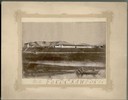
| Date: | 1840 |
|---|---|
| Description: | Photograph of a painting of the second Fort Crawford, built 1829-1835. Two men are in a boat in the water in the foreground. The first Fort Crawford at Pra... |

| Date: | 1848 |
|---|---|
| Description: | The first Fort Crawford at Prairie du Chien, with the Mississippi River in the foreground. Although dated 1830, this scene was actually painted by Henry Le... |
| Date: | |
|---|---|
| Description: | Drawing of a section of a completed part of Fort Cairo facing the confluen [sic] of the Mississippi and Ohio rivers. |
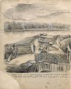
| Date: | 04 1862 |
|---|---|
| Description: | Notes include: Sketch of Battle of Island #10. Sketch of Fort Pillow Tennessee. Gen. Pope had command of the land troops. |

| Date: | 1840 |
|---|---|
| Description: | Fort Crawford (the second site, with buildings of 1829-?), on the east bank of the Mississippi River, about 2 miles above the mouth of the Wisconsin River. |

| Date: | 1829 |
|---|---|
| Description: | Fort Crawford, from a sketchbook attributed to Seth Eastman, 1808-1875. A graduate of West Point, Eastman briefly served at Fort Crawford, 1829-1839. |

| Date: | 1829 |
|---|---|
| Description: | Hand-colored lithograph of Fort Armstrong on Rock Island, based on a drawing by Henry Lewis. Foreground shows a tree floating in the water. |

| Date: | 1829 |
|---|---|
| Description: | Hand-colored lithograph of Fort Armstrong, based on a drawing by Henry Lewis. Includes boats on the Mississippi River. |

| Date: | |
|---|---|
| Description: | Preliminary sketch for "Fort Pillow upon the Eve of the Evacuation by the Rebels". |

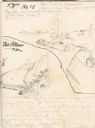
| Date: | 1862 |
|---|---|
| Description: | This map lists and depicts the positions of "the batteries on Kentucky shore" and the "batteries on Island No. 10." The 8th Wisconsin Infantry and 15th Wis... |

| Date: | 1850 |
|---|---|
| Description: | A hand-colored map showing portions of present-day Iron and Vilas counties north of the Manitowish River as part of the Upper Peninsula of Michigan. The Wi... |

| Date: | 1852 |
|---|---|
| Description: | A hand-colored map showing portions of present-day Iron and Vilas counties north of the Manitowish River as part of the Upper Peninsula of Michigan. The Wi... |

| Date: | 1972 |
|---|---|
| Description: | Ink on tracing paper. This map shows rivers, Prairie du Chien, site of Fort Crawford, Excelsior, Fort Andrew, Boscobel, Blue River, Orion, Muscoda, Castle ... |

| Date: | 1882 |
|---|---|
| Description: | This map is ink on cardboard and shows the location of military forts over the course of years. Also shown are points of interest, streets, the Mississippi... |

| Date: | 01 15 1929 |
|---|---|
| Description: | Intended for tourists, this brochure, titled: "Winneshiek World’s Famous Wild Life Refuge Historic Fort Crawford and Picturesque Prairie du Chien," feature... |

| Date: | 1950 |
|---|---|
| Description: | Intended for tourists, this brochure features two maps with tourists sites along the Mississippi River. One map shows roads and populated places along the ... |

| Date: | 1856 |
|---|---|
| Description: | This map shows lot and block numbers, streets, the Mississippi River, Fort Crawford, depot ground, and a graveyard. An old fort location is outlined in red... |

| Date: | 12 05 1854 |
|---|---|
| Description: | This plat map shows landowners, the Mississippi River, the Marais de St. Friole, and an old fort. The left margin reads: "Part of the Main Village of Prair... |

| Date: | 1828 |
|---|---|
| Description: | This plat map is pen-and-ink and shows landowners, the Mississippi River, the Marais de St. Friole, Fort Crawford, the town commons, and the Village of St.... |
If you didn't find the material you searched for, our Library Reference Staff can help.
Call our reference desk at 608-264-6535 or email us at: