| Date: | |
|---|---|
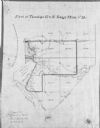
| Description: | A hand-drawn map of the state of Missouri with a separate drawing of a map showing Forts Henry and Donelson. The Missouri map includes Jefferson City and s... |

| Date: | |
|---|---|
| Description: | Sketch of the Fort at Michilimackinac (also called Mackinac) as it was under French rule. |

| Date: | 1855 |
|---|---|
| Description: | Fox-Wisconsin portage and canal map, when the canal was not yet built. From a map in the office of the city clerk at Portage. "The old trail, the location ... |

| Date: | 1806 |
|---|---|
| Description: | Prehistoric Indian fortification on Hurricane Creek. |

| Date: | |
|---|---|
| Description: | A map of the prehistoric fort at Circleville with annotations by Daniel Drake. |

| Date: | 1900 |
|---|---|
| Description: | This manuscript map shows outline of Fort Winnebago reserve land, Fort Winnebago, claim of A. Grignon, and Indian boundaries. The Fox River and Swan Lake a... |

| Date: | 1990 |
|---|---|
| Description: | This map, in addition to the Fort ground and buildings, shows owners of outbuildings, heights of buildings in stories, fences, roads, gardens, and cemetery... |

| Date: | 1719 |
|---|---|
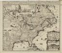
| Description: | This extremely detailed and ornate map shows the cities, Native American land, mountains, lakes, rivers, and European claims of North America. An inset map... |

| Date: | 1755 |
|---|---|
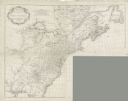
| Description: | Large format map of America and Canada east of the Mississippi River. D'Anville marks the locations of rivers, lakes, settlements, cities, Native American ... |

| Date: | 1755 |
|---|---|
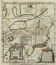
| Description: | Map of New England, with three inset maps of Fort Oswego, Fort du Quesne, and Fort Frederick. It shows colonies, a few cities, forts (marked as French or E... |
If you didn't find the material you searched for, our Library Reference Staff can help.
Call our reference desk at 608-264-6535 or email us at: