 Filter: Categories of Wisconsin Historical Images
Filter: Subject of Fortification
Filter: County of Crawford
Filter: Categories of Wisconsin Historical Images
Filter: Subject of Fortification
Filter: County of Crawford

| Date: | 07 28 1934 |
|---|---|
| Description: | This map shows buildings and dimensions of Fort Crawford and hospital overlaid on a plat of existing lots, streets, and closed streets. |

| Date: | |
|---|---|
| Description: | This map is pen-and-ink on tracing paper with a mounted legend and shows the Kickapoo River, Indian mounds, the 1st Fort Crawford, an Indian Agency, the si... |

| Date: | 1900 |
|---|---|
| Description: | This photocopy map shows proposed buildings and building use at Fort Crawford. |

| Date: | 1900 |
|---|---|
| Description: | This photocopy map shows marshes, woods, buildings, and selected features including islands, mounds, old Fort Crawford, and "new site for a fort in questio... |

| Date: | 1839 |
|---|---|
| Description: | This map shows the geological makeup of the valley in red, yellow, and green, the Mississippi River, and the location of Fort Crawford. The geology on the ... |
| Date: | |
|---|---|
| Description: | Elevated view of Fort Crawford facing west showing north row of buildings. The Mississippi River is in the background. Typewritten caption reads: "Fort Cra... |

| Date: | 1938 |
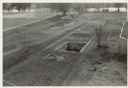
|---|---|
| Description: | A horizontal view of the palisade between old Fort Crawford and the military hospital. The number "30" has been placed in the trench on the left. |
| Date: | |
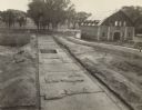
|---|---|
| Description: | Completed excavations at Fort Crawford showing the north row of buildings. Caption reads: "N. Row Bldgs. Completed excavations, Ft. Crawford." |

| Date: | |
|---|---|
| Description: | The Fort Crawford site showing the main water trench to the swimming pool. Caption reads: "Discovery of Ft. Crawford — Water Main Trench to swimming pool p... |
If you didn't find the material you searched for, our Library Reference Staff can help.
Call our reference desk at 608-264-6535 or email us at: