 Filter: Categories of Wisconsin Historical Images
Filter: Subject of Formations (Geology)
Filter: Year of 1800-1899
Filter: Year of 1840-1849
Filter: Categories of Wisconsin Historical Images
Filter: Subject of Formations (Geology)
Filter: Year of 1800-1899
Filter: Year of 1840-1849
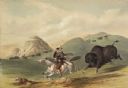
| Date: | 1844 |
|---|---|
| Description: | Buffalo chasing hunter with rifle on horseback (Plate 12). "The wounded and chafed bull often turns upon its assailant, and runs him back, over the whole... |

| Date: | 1849 |
|---|---|
| Description: | Pencil sketch of a cross-section of the Dells of the Wisconsin River. People are in a row boat in the center. Caption at bottom: "The Dells — Wisconsin Riv... |

| Date: | 1844 |
|---|---|
| Description: | A hand-colored map and chart showing a geological cross-section from Rockingham, in present-day Scott County, Iowa, through Blue Mounds to the Wisconsin Ri... |

| Date: | 1847 |
|---|---|
| Description: | A hand-colored map that shows the area south and east of the Wisconsin and Fox Rivers, as well as a few landmarks just north of that area. The township gri... |

| Date: | 1842 |
|---|---|
| Description: | This map shows portions of northern Illinois and Wisconsin surveyed by the map's creation. It shows county lines and university land, and depicts lead and ... |

| Date: | 1847 |
|---|---|
| Description: | A geological, hand-colored map of Wisconsin north and west of the Wisconsin River, as well as portions of eastern Minnesota and Iowa from the Mississippi t... |
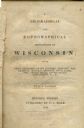
| Date: | 1844 |
|---|---|
| Description: | Title page of Increase Lapham's A Geographical and Topographical Description of Wisconsin published by P.C. Hale of Milwaukee, Wisconsin. |

| Date: | 1847 |
|---|---|
| Description: | This map identifies surveyed areas of the Upper Peninsula and shows lakes, rivers, and islands in portions of Wisconsin, Minnesota, Michigan, and upper Can... |
If you didn't find the material you searched for, our Library Reference Staff can help.
Call our reference desk at 608-264-6535 or email us at:
