 Filter: Categories of Wisconsin Historical Images
Filter: Subject of Formations (Geology)
Filter: Year of 1800-1899
Filter: Categories of Wisconsin Historical Images
Filter: Subject of Formations (Geology)
Filter: Year of 1800-1899

| Date: | 1842 |
|---|---|
| Description: | This map shows portions of northern Illinois and Wisconsin surveyed by the map's creation. It shows county lines and university land, and depicts lead and ... |

| Date: | 1847 |
|---|---|
| Description: | A geological, hand-colored map of Wisconsin north and west of the Wisconsin River, as well as portions of eastern Minnesota and Iowa from the Mississippi t... |

| Date: | 1874 |
|---|---|
| Description: | This map of Wisconsin shows cities, counties, railroads already completed and railroads projected, and geological makeup of the land such as lakes. |

| Date: | 1869 |
|---|---|
| Description: | This geological map shows the township grid, counties, cities and villages, rivers, lakes, railroads, and roads. Barron County is still labeled Dallas Coun... |

| Date: | 1853 |
|---|---|
| Description: | Engraved image of a boat being towed through a canal at Little Falls by a team of horses. A small town is in the background. |

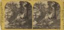
| Date: | 06 24 1878 |
|---|---|
| Description: | Stereograph of three men at the top of Stand Rock. One man is standing holding his rifle, while the two other people are sitting. Text at right: "Wandering... |
| Date: | 1869 |
|---|---|
| Description: | Two girls in long dresses on a rock formation. The river and far shoreline is in the background. Text on left reads: "A Visit to Devil's Lake, Sauk County,... |
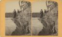
| Date: | 03 22 1889 |
|---|---|
| Description: | Evaline Helen Marshall and unidentified woman on a rock cliff over Devil's Lake. |
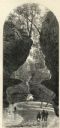
| Date: | 1874 |
|---|---|
| Description: | Engraved view of Rood's Glen. A boy plays with a toy boat at bottom left while two men and a woman talk at bottom right. Two other figures can be seen in t... |
| Date: | 1874 |
|---|---|
| Description: | Engraved view of Maiden's Rock at Lake Pepin. A steamboat is on the Mississippi River. |
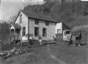
| Date: | 1890 |
|---|---|
| Description: | On the right a mailman is standing with his horse and cart. The cart is labeled "RFD Route No.1" and "U.S. Mail." Members of his family, one boy and one gi... |

| Date: | 1867 |
|---|---|
| Description: | This 1867 manuscript map by Increase Lapham shows the topography and geology of the Blue Mounds region in the Town of Brigham in Iowa County and the towns ... |

| Date: | 1891 |
|---|---|
| Description: | Map shows Iron and Dickinson Counties, Mich. and Florence County, Wis. "Nov. 1st, 1891." Irregularly shaped. Includes table of distances and township diagr... |

| Date: | 1875 |
|---|---|
| Description: | These maps, from G.K. Warren's 1876 Report on the transportation route along the Wisconsin and Fox rivers in the State of Wisconsin between the Mississippi... |

| Date: | 1866 |
|---|---|
| Description: | This manuscript map by Increase Lapham shows the Dells of the Wisconsin River, from Stand Rock and Witches Gulch at the north to a point approximately one ... |
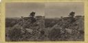
| Date: | 1863 |
|---|---|
| Description: | Stereograph of breast works on a rocky outcropping on the site of the Battle of Gettysburg. A man can be seen standing behind the breast works. He is gazin... |

| Date: | 1863 |
|---|---|
| Description: | Stereograph of Round Top Mountain, near the site of the Gettysburg battlefield. A man sits on a stump, shading his eyes with his hand, gazing at the mounta... |
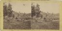
| Date: | 1863 |
|---|---|
| Description: | Stereograph of a scene near the site of the Gettysburg battlefield. Two men sit in a wagon in the center of the image. |
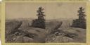
| Date: | 07 1863 |
|---|---|
| Description: | Stereograph of Signal Rock (signal station) on top of Little Round Top at the site of the Gettysburg battlefield. This shows the center of the Federal posi... |

| Date: | 12 22 1830 |
|---|---|
| Description: | Increase Lapham's drawing of the geological profile between the Sandusky plains and Portsmouth, Ohio. |
If you didn't find the material you searched for, our Library Reference Staff can help.
Call our reference desk at 608-264-6535 or email us at: