Filter: Categories of Wisconsin Historical Images
Filter: Subject of Formations (Geology)
Filter: Subject of streams
Filter: Categories of Wisconsin Historical Images
Filter: Subject of Formations (Geology)
Filter: Subject of streams

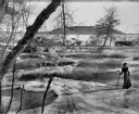
| Date: | 1876 |
|---|---|
| Description: | View of a farmstead with fences, haystacks and a wooden outbuilding. Two men are posing on top of McCord Rock, one of them saluting with his hat. Another ... |
| Date: | 1950 |
|---|---|
| Description: | View looking up at the Methodist Episcopal church over tree covered formations on the banks of Arkansaw Creek. |
| Date: | 1909 |
|---|---|
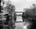
| Description: | View from river of Dell Creek bridge with bluff and birch trees on the left. |
| Date: | |
|---|---|
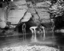
| Description: | Four young men wade in the water at the base of a rock, one holding a fishing pole. The young men could possibly be the Taylor boys catching minnows in Per... |
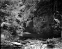
| Date: | 1910 |
|---|---|
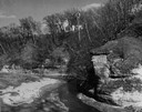
| Description: | A view of a ravine showing rock strata and a stream. |
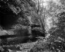
| Date: | 1909 |
|---|---|
| Description: | A view of the "Glen of the Calydon" showing a stream and rock formations. |

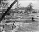
| Date: | 1909 |
|---|---|
| Description: | View of Skillet Falls from downstream. The trees are bare, and tree stumps are visible on the hill in the background, known locally as Mount Baldy. |
| Date: | 1909 |
|---|---|
| Description: | Elevated view of a woman holding a walking stick and wearing a hat and fur coat with a fur stole sitting on a ledge of ice at Skillet Falls. Bare trees fra... |
| Date: | 1909 |
|---|---|
| Description: | Two well-dressed women stand at the foot of Skillet Falls. The trees in the background are bare; the hill behind is covered with tree stumps. The hill is... |
| Date: | 1909 |
|---|---|
| Description: | A well-dressed woman with a walking stick stands on ice at the partially frozen Skillet Falls. Bare trees frame the scene. There are patches of snow and tr... |
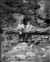
| Date: | 1909 |
|---|---|
| Description: | Two women pose behind a log which has fallen across the stream in Parfrey's Glen. One woman holds a small pail. |
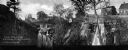
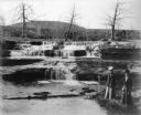
| Date: | |
|---|---|
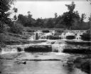
| Description: | View toward two waterfalls flowing over rocks into a ravine. One waterfall is held back by a dam and the other is traversed by a railroad bridge. Trees and... |

| Date: | |
|---|---|
| Description: | A hand-drawn Geological map of the Upper Peninsula of Michigan, showing the counties and streams of that area. The map also identifies the location of the... |

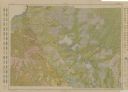
| Date: | 1911 |
|---|---|
| Description: | This map, taken from the 1911 Map of Wisconsin showing geology and roads by Hotchkiss and Thwaites, shows the northwest portion of Douglas County, Wisconsi... |

| Date: | 1911 |
|---|---|
| Description: | This 1911 map of the geology of northern Wisconsin between Superior and Hurley was published by the Wisconsin Geological and Natural History Survey in Fred... |

| Date: | 1867 |
|---|---|
| Description: | This 1867 manuscript map by Increase Lapham shows the topography and geology of the Blue Mounds region in the Town of Brigham in Iowa County and the towns ... |

| Date: | 1891 |
|---|---|
| Description: | Map shows Iron and Dickinson Counties, Mich. and Florence County, Wis. "Nov. 1st, 1891." Irregularly shaped. Includes table of distances and township diagr... |

| Date: | 1866 |
|---|---|
| Description: | This manuscript map by Increase Lapham shows the Dells of the Wisconsin River, from Stand Rock and Witches Gulch at the north to a point approximately one ... |
| Date: | 1913 |
|---|---|
| Description: | Shows soil types by colors and symbols. Relief shown by contours. Soils surveyed by W.J. Geib, Arthur E. Taylor and Guy Conrey. "Base map in part from U.S.... |
If you didn't find the material you searched for, our Library Reference Staff can help.
Call our reference desk at 608-264-6535 or email us at: