 Filter: Categories of Wisconsin Historical Images
Filter: Subject of Formations (Geology)
Filter: Subject of michigan, lake
Filter: Categories of Wisconsin Historical Images
Filter: Subject of Formations (Geology)
Filter: Subject of michigan, lake
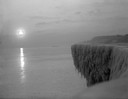
| Date: | 1912 |
|---|---|
| Description: | Sunrise over a frozen cliff on Lake Michigan. |
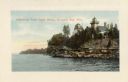
| Date: | 1915 |
|---|---|
| Description: | Colorized view of the Sherwood Point Lighthouse. Caption reads: "Sherwood Point Light House, Sturgeon Bay, Wis." |
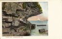
| Date: | 1910 |
|---|---|
| Description: | View of Lover's Leap, with a group of people posing on the rocks and sailboats in the background. Caption reads: "Lover's Leap, Sturgeon Bay, Wis." |
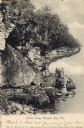
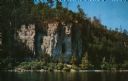
| Date: | 1906 |
|---|---|
| Description: | View of Lover's Leap with a group of people on the rocks near the shoreline under an overhang. Caption reads: "Lovers Leap, Sturgeon Bay, Wis." |
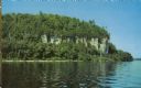
| Date: | 1960 |
|---|---|
| Description: | View across water towards the 180-foot high Eagle Bluff. The bluff received its name from the eagles which formerly nested there. |
| Date: | 1960 |
|---|---|
| Description: | View across water towards the 180-foot high Eagle Bluff. The bluff received its name from the eagles which formerly nested there. |
| Date: | 1936 |
|---|---|
| Description: | Elevated view of the Lake Michigan shoreline and the rocks at Cave Point. |

| Date: | 1968 |
|---|---|
| Description: | This map shows lakes, rivers and soil types. Lake Michigan, Lake Superior, and portions of Illinois, Iowa, Michigan, and Minnesota are labeled. A legend to... |

| Date: | 1928 |
|---|---|
| Description: | This map shows geological formations throughout Wisconsin. Lakes and rivers are labeled, including The Mississippi River, Lake Superior, and Lake Michigan.... |

| Date: | 1855 |
|---|---|
| Description: | This map shows counties, cities, rivers, canals, lakes, railroads, common roads, county towns, townships, villages, and post offices. The map includes part... |

| Date: | 1864 |
|---|---|
| Description: | A geological map of Wisconsin that shows the locations of different rock deposits such as limestone, sandstone, shale, plutonic and the Penokee Iron Range.... |

| Date: | 1882 |
|---|---|
| Description: | A geological map of northern Wisconsin showing the locations of different soil types in the state such as sandy soil, sandy loam, prairie loam, clayey loam... |

| Date: | 1847 |
|---|---|
| Description: | A hand-colored map that shows the area south and east of the Wisconsin and Fox Rivers, as well as a few landmarks just north of that area. The township gri... |

| Date: | 1874 |
|---|---|
| Description: | This map of Wisconsin shows cities, counties, railroads already completed and railroads projected, and geological makeup of the land such as lakes. |

| Date: | 1869 |
|---|---|
| Description: | This geological map shows the township grid, counties, cities and villages, rivers, lakes, railroads, and roads. Barron County is still labeled Dallas Coun... |
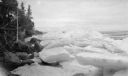
| Date: | 04 1922 |
|---|---|
| Description: | Large slabs and piles of ice line the rocky shoreline of Lake Michigan, possibly at Europe Bay. |
| Date: | 07 1923 |
|---|---|
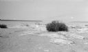
| Description: | A grassy hummock stands out on the beach at Gravelly Island. |
| Date: | 07 1923 |
|---|---|
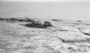
| Description: | Members of the photographer's family shield their heads with their clothing while walking among grassy hummocks on Gravelly Island. There are many seagulls... |
| Date: | 1927 |
|---|---|
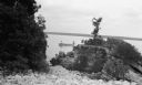
| Description: | Rock outcroppings overhang a Door County beach. |
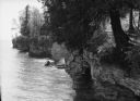
| Date: | 1942 |
|---|---|
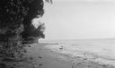
| Description: | View from rocky shoreline of two men fishing from a small boat near Toft Point. |
If you didn't find the material you searched for, our Library Reference Staff can help.
Call our reference desk at 608-264-6535 or email us at: