Filter: Categories of Wisconsin Historical Images
Filter: Subject of Formations (Geology)
Filter: Reproduction Rights of For Sale
Filter: Year of 1900-1999
Filter: Year of 1950-1959
Filter: Categories of Wisconsin Historical Images
Filter: Subject of Formations (Geology)
Filter: Reproduction Rights of For Sale
Filter: Year of 1900-1999
Filter: Year of 1950-1959
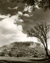
| Date: | 1950 |
|---|---|
| Description: | View looking up at the Methodist Episcopal church over tree covered formations on the banks of Arkansaw Creek. |

| Date: | 1954 |
|---|---|
| Description: | Raddatz Rockshelter and Natural Bridge, known by archaeologists as 47 SK-5. The bridge is made of sand stone, reaching 35 feet in height, and is the larges... |
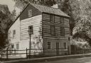
| Date: | 1953 |
|---|---|
| Description: | A restored Cornish miner's house, called Polperro, on Shake Rag Street. The house was temporarily covered with siding, but after restoration the siding was... |

| Date: | 1955 |
|---|---|
| Description: | A restored Cornish miner's house, called Polperro, on Shake Rag Street. The house was temporarily covered with siding, but after restoration the siding was... |
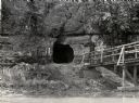
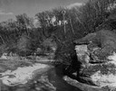
| Date: | 1950 |
|---|---|
| Description: | View across river towards the tunnel leading to the bottom of the shot tower shaft at Tower Hill State Park. There is a rustic bridge on the right leading ... |

| Date: | 05 09 1957 |
|---|---|
| Description: | Prudential girls taking pictures in the Dells. |
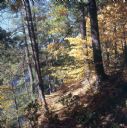
| Date: | 1950 |
|---|---|
| Description: | Hillside path at Narrows during the Fall. The river is visible beyond trees on the left. |
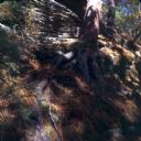
| Date: | 1950 |
|---|---|
| Description: | Pine tree on hillside path at Narrows during the Fall. |

| Date: | 1952 |
|---|---|
| Description: | The famous Dells of the Wisconsin River. A souvenir map embellished with bits of history and points of interest. |
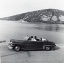
| Date: | 1956 |
|---|---|
| Description: | Lewis, LuRay, Nellie and Bernard Arms arrive at Devil's Lake in a maroon DeSoto convertible automobile. This was the day after Lewis and LuRay's wedding. |

| Date: | 1956 |
|---|---|
| Description: | Color postcard view looking down at the rock formation called the Devil's Doorway in Devil's Lake State Park. The lake, bluffs and sky are in the backgroun... |

| Date: | 1957 |
|---|---|
| Description: | Color postcard of Dream River, North Cave, opened in 1957, in the Cave of the Mounds. |
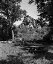
| Date: | 06 27 1954 |
|---|---|
| Description: | Two people walk near a large rock formation in a wooded area with a picnic table in the foreground. The occasion was the opening of a new wayside park loca... |
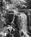
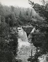
| Date: | 1952 |
|---|---|
| Description: | "This waterfall is located on Hocheim Road southwest of Theresa." |
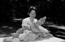
| Date: | 06 21 1959 |
|---|---|
| Description: | Nancy Muckenhirn is shown with Devil's Lake rocks that the Black Hawk Council of Girl Scouts will be taking to Colorado Springs for the Senior Girl Scout R... |

| Date: | 1950 |
|---|---|
| Description: | A fisherman poses on rocks with his fishing pole and a stringer of fish. |

| Date: | 1956 |
|---|---|
| Description: | This map is intended for tourists of La Crosse. The front of the map is text about attractions, activities, and accommodations in La Crosse. The back is th... |

| Date: | 1959 |
|---|---|
| Description: | Slightly elevated view of Ho Chunk performing at the Stand Rock Indian Ceremonial at night. A group of men, women and children are dancing in a circle, wea... |
If you didn't find the material you searched for, our Library Reference Staff can help.
Call our reference desk at 608-264-6535 or email us at: