Filter: Categories of Wisconsin Historical Images
Filter: Subject of Forests and forestry
Filter: Subject of water
Filter: Year of 1800-1899
Filter: Categories of Wisconsin Historical Images
Filter: Subject of Forests and forestry
Filter: Subject of water
Filter: Year of 1800-1899

| Date: | 10 1852 |
|---|---|
| Description: | Landscape view of the river looking downstream from Fort Snelling, Minnesota Territory. An expanse of placid river water fills the center of the drawing an... |

| Date: | 1883 |
|---|---|
| Description: | Bird's-eye map of Sauk City. |
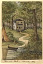
| Date: | 1858 |
|---|---|
| Description: | This house, built on a hill close to the Milwaukee River, was the only one in the city as late as 1840. The owner of the house, Martin [Matthias] Stein, a ... |
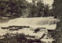
| Date: | 1880 |
|---|---|
| Description: | Willow River Falls. Text at right reads: "Published by Whitney's Gallery, St. Paul, Minn. Willow River Falls Near Hudeson, Wis." |

| Date: | 03 15 1896 |
|---|---|
| Description: | Winter view down Capitol Avenue, possibly in Maple Bluff. |
| Date: | 05 12 1894 |
|---|---|
| Description: | View from the Ohio River of the West Virginia shoreline. |
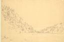
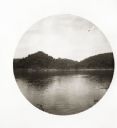
| Date: | 1852 |
|---|---|
| Description: | Devil's Lake from shore flanked by steep tree-covered hillsides. A small solitary rowboat floats near the distant shore. |

| Date: | 1861 |
|---|---|
| Description: | Shows townships and sections, landowners, and woodlands. Includes inset maps of Monroe, Brodhead, Albany, Cadiz, Decatur, Dayton, Clarence, Springfield, Tw... |
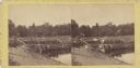
| Date: | 07 1863 |
|---|---|
| Description: | Stereograph of McPherson's Woods, where General John Reynolds, commanding the First Corps of which Wisconsin's 2nd, 6th, and 7th regiments were a part, was... |
| Date: | 1898 |
|---|---|
| Description: | Colorized postcard view of the Devil's Doorway rock formation overlooking Devil's Lake. Caption reads: "Devil's Doorway, Devil's Lake, Wis." |
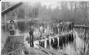
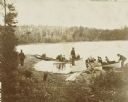
| Date: | 1890 |
|---|---|
| Description: | View from shoreline of a driving crew standing on a log raft on the North Branch of the Popple River, a tributary of the Pine River. They are holding long ... |
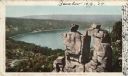
| Date: | 1860 |
|---|---|
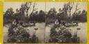
| Description: | Two men and two women visit sit on a small, rocky island or natural bridge near water. Plants and trees are on shoreline behind them. |

| Date: | 1858 |
|---|---|
| Description: | This map shows city wards, streets, block and lot numbers, cemeteries, buildings, landownership, forests, railroads, a race course, quarries, and orchards.... |

| Date: | 1898 |
|---|---|
| Description: | This map shows the conditions of the forest. Includes a color legend in left margin, depicting the various conditions. Original caption reads, "Compiled by... |

| Date: | 1862 |
|---|---|
| Description: | This map shows the population by county, the basic geology, climate, and the distribution of timber within the state of Wisconsin. It shows mean seasonal t... |

| Date: | 1831 |
|---|---|
| Description: | This map shows the land that makes up Michigan, Wisconsin, Minnesota, Indiana, and parts of Canada. The Great Lakes are displayed prominently, along with s... |
| Date: | 1898 |
|---|---|
| Description: | View across the water towards George Holt paddling a clinker-built duck boat on Archibald Lake. Caption reads: "At sea." |
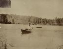
| Date: | 08 24 1898 |
|---|---|
| Description: | A group of Holt family members and guests is arriving at the Island on Archibald Lake, with lumberjacks from Holt Lumber Company rowing the boats. The man ... |
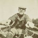
| Date: | 1898 |
|---|---|
| Description: | Close-up of a young man, possibly James McClure, Jr., rowing on Archibald Lake. A tree-lined shore is in the background. Caption reads: "A Great Hand at Ro... |
If you didn't find the material you searched for, our Library Reference Staff can help.
Call our reference desk at 608-264-6535 or email us at: