 Filter: Categories of Wisconsin Historical Images
Filter: Subject of Forests and forestry
Filter: Subject of water
Filter: Subject of land use
Filter: Categories of Wisconsin Historical Images
Filter: Subject of Forests and forestry
Filter: Subject of water
Filter: Subject of land use

| Date: | 1951 |
|---|---|
| Description: | Aerial view of the Nekoosa-Edwards Paper Company nursery. |

| Date: | 03 24 1913 |
|---|---|
| Description: | Picnic Point from the University Farm fields, now known as Observatory Hill. |
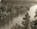
| Date: | 1940 |
|---|---|
| Description: | Elevated view of a canoe on the St. Croix River with wooded areas on both sides within the Interstate State Park. Established in 1900, Interstate Park was... |

| Date: | 1939 |
|---|---|
| Description: | A color, pictorial map. Scale: 10 miles to the inch. Shows state parks and forests, proposed state parkways, proposed state monuments and memorials, nation... |
| Date: | |
|---|---|
| Description: | Rustic log footbridge over a creek in the woods. |

| Date: | 06 23 1937 |
|---|---|
| Description: | A man in an International D-30 truck used by the Township of Monck is parked in front of a wooded area and body of water. He is talking to a man standing n... |
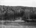
| Date: | 09 17 1961 |
|---|---|
| Description: | View down hill towards backwater area of the Wolf River, near it's source, surrounded by thick woods. Crop marks indicated by photographer. |
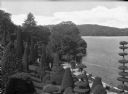
| Date: | |
|---|---|
| Description: | Elevated view of Hunnewell arboretum featuring a a hill with rows of topiary, Lake Wauban and surrounding woods. |
| Date: | |
|---|---|
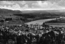
| Description: | Elevated view of country town showing large. There are wooden buildings alongside the Delaware River which curves through fields and patches of woods in th... |
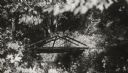
| Date: | |
|---|---|
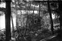
| Description: | Elevated view of White Birch Lodge. A log walkway leads to the rustic summer house surrounded by trees. A body of water stands in the background. |
| Date: | |
|---|---|
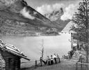
| Description: | View of Going-to-the-Sun Chalets at Glacier National Park. View features rustic chalets overlooking the river and hills. Several people stand by the river ... |

| Date: | 07 15 1958 |
|---|---|
| Description: | Aerial view of Eagle Heights Farm, Eagle Heights Woods and part of Lake Mendota. Sites labeled on the image are Eagle Heights, Tent Colony, Apartment Site,... |
| Date: | 1930 |
|---|---|
| Description: | View from hill of a farm near a pond. There are homes along the far shoreline, and a lake and hills in the far background. |

| Date: | 1935 |
|---|---|
| Description: | This map shows in different colors virgin timberland, second growth timber, pasture belt, crop-pasture belt, intensive crop-pasture belt, intensive pasture... |
| Date: | 1924 |
|---|---|
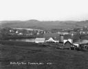
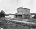
| Description: | The Humbird Roller Mill surrounded by rural landscape. A man leads on a porch beam as he poses for the picture. |

| Date: | |
|---|---|
| Description: | Map of northern Iron County, Wisconsin, shows town sections and railroads in the towns of Saxon, Kimball, and Gurney. It also includes the area of the La P... |

| Date: | 1930 |
|---|---|
| Description: | Aerial view, looking northeast, across Mud Lake with North Bay in the background, showing cultivated fields and wooded land. |

| Date: | 1930 |
|---|---|
| Description: | Aerial view of the northern tip of the Door Peninsula, looking north. Europe Lake is in the center, with Europe Bay to the right. Plum Island and Washingto... |

| Date: | 1960 |
|---|---|
| Description: | This mid-20th century tourist brochure for Bayfield County, Wisconsin, includes a map of the county showing towns, cities and villages, highways and roads,... |
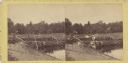
| Date: | 07 1863 |
|---|---|
| Description: | Stereograph of McPherson's Woods, where General John Reynolds, commanding the First Corps of which Wisconsin's 2nd, 6th, and 7th regiments were a part, was... |
If you didn't find the material you searched for, our Library Reference Staff can help.
Call our reference desk at 608-264-6535 or email us at: