 Filter: Categories of Wisconsin Historical Images
Filter: Subject of Forests and forestry
Filter: Subject of fortification
Filter: Categories of Wisconsin Historical Images
Filter: Subject of Forests and forestry
Filter: Subject of fortification

| Date: | |
|---|---|
| Description: | Elevated view of Fort Seward from Mount Rippinsky, showing Pyramid Harbor and Davidson Glacier in distance. Caption reads: "Haines and Fort Wm. H. Seward f... |
| Date: | 07 1863 |
|---|---|
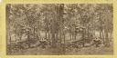
| Description: | A stereograph made by Mathew Brady about two weeks after the battle of Gettysburg, showing his two assistants gazing eastward from the extreme right of the... |
| Date: | 1918 |
|---|---|
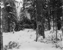
| Description: | View across snow towards a camouflaged log blockhouse constructed during the Allied Intervention in Northern Russia. The fortification is surrounded by a f... |
| Date: | 1918 |
|---|---|
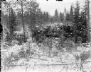
| Description: | View through trees and branches of a log blockhouse fortification used by the Allied forces. The fortification is in a heavily forested area and camouflage... |
| Date: | 1918 |
|---|---|
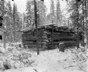
| Description: | A log blockhouse under construction to support the Allied Intervention in Northern Russia. The fortification is surrounded by a forested area covered in sn... |
| Date: | 1918 |
|---|---|
| Description: | Trenches constructed for American forces to defend against the Bolshevik "Red" forces. In the background are possibly barracks and other buildings for the ... |

| Date: | 1918 |
|---|---|
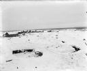
| Description: | View over slashed timber towards the edge of the defenses, with camouflaged blockhouse in the background. |

| Date: | 1918 |
|---|---|
| Description: | Two men stand behind a heavily camouflaged machine gun emplacement in a forested area. On the far right a uniformed solider is sitting up in a tree. |

| Date: | 1918 |
|---|---|
| Description: | Blockhouse fortification under construction in a forested area. There are two uniformed soldiers standing on the right. |

| Date: | 1918 |
|---|---|
| Description: | Three uniformed soldiers in the process of constructing Blockhouse No. 8 with logs and earth. The area appears to overlook a ravine. |

| Date: | 1900 |
|---|---|
| Description: | This map shows portion of the military road from Fond du Lac to the Wisconsin River near Fort Winnebago, with mile markers and adjacent land use. A few pro... |

| Date: | 1900 |
|---|---|
| Description: | This photocopy map shows marshes, woods, buildings, and selected features including islands, mounds, old Fort Crawford, and "new site for a fort in questio... |

| Date: | 03 1777 |
|---|---|
| Description: | Map showing the British and Hessian attack on Fort Washington in November of 1776. The movements and fortifications of the British and Hessian troops appea... |

| Date: | 1776 |
|---|---|
| Description: | Fairly detailed map of New York City and parts of Long Island. It shows streets, roads, wharves, ferries, ship yards, Fort George and the battery, public b... |

| Date: | |
|---|---|
| Description: | Photograph taken on the set of the 1936 film "The Last of the Mohicans" of British soldiers peering over a wooden wall. They are looking at a group of Fre... |
If you didn't find the material you searched for, our Library Reference Staff can help.
Call our reference desk at 608-264-6535 or email us at: