 Filter: Categories of Wisconsin Historical Images
Filter: Subject of Forests and forestry
Filter: Type of Map or Atlas
Filter: Subject of cities and towns
Filter: Categories of Wisconsin Historical Images
Filter: Subject of Forests and forestry
Filter: Type of Map or Atlas
Filter: Subject of cities and towns

| Date: | 1883 |
|---|---|
| Description: | Bird's-eye map of Sauk City. |

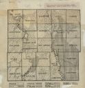
| Date: | 1861 |
|---|---|
| Description: | Shows townships and sections, landowners, and woodlands. Includes inset maps of Monroe, Brodhead, Albany, Cadiz, Decatur, Dayton, Clarence, Springfield, Tw... |

| Date: | 1935 |
|---|---|
| Description: | This map shows in different colors virgin timberland, second growth timber, pasture belt, crop-pasture belt, intensive crop-pasture belt, intensive pasture... |

| Date: | 1933 |
|---|---|
| Description: | A road map of Wisconsin and Michigan’s Upper Peninsula, showing the populations of cities and villages, state and federal highways, national forests, state... |

| Date: | 1944 |
|---|---|
| Description: | This nine-part map from the U.S. Bureau of Public Roads identifies federal and state highways in Wisconsin by pavement type. County, forest, park, and publ... |

| Date: | 1906 |
|---|---|
| Description: | A hand-colored commercial map of Wisconsin and portions of eastern Minnesota, Iowa, northern Illinois, and the Michigan’s Upper Peninsula. The map shows ra... |

| Date: | |
|---|---|
| Description: | Map of northern Iron County, Wisconsin, shows town sections and railroads in the towns of Saxon, Kimball, and Gurney. It also includes the area of the La P... |

| Date: | 1920 |
|---|---|
| Description: | This early 1920s map shows state-owned land in townships 38 and 39, range 7 east, the towns of Lake Tomahawk and Woodruff, in Oneida County, Wisconsin, tha... |

| Date: | 1959 |
|---|---|
| Description: | This map identifies public forest land and industrial forest land as of 1959 in Oneida County, Wisconsin, using a 1930 base map showing the township and ra... |

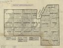
| Date: | 1940 |
|---|---|
| Description: | This map of Taylor County, Wisconsin, shows the township and range grid, towns, sections, cities and villages, railroads, roads, creameries and cheese fact... |

| Date: | 1960 |
|---|---|
| Description: | This mid-20th century tourist brochure for Bayfield County, Wisconsin, includes a map of the county showing towns, cities and villages, highways and roads,... |

| Date: | 1967 |
|---|---|
| Description: | This tourist brochure for Bayfield County, Wisconsin, from 1967 includes a map of the county showing towns, cities and villages, highways and roads, railro... |
| Date: | 1922 |
|---|---|
| Description: | This early 20th century manuscript map shows prairie, maple, maple and beech, marsh conifer, oak, oak and maple, and grass and sedge areas by town in Dodge... |
| Date: | 1930 |
|---|---|
| Description: | Map shows prairie, oak, maple, oak and maple, marsh conifer, maple and beech, and grass and sedge. |

| Date: | 1937 |
|---|---|
| Description: | "Prepared ... March 1937." Includes location map. "State of Wisconsin, Conservation Department, Map Division"--upper left. From the E.P. Sherry papers rela... |

| Date: | 1935 |
|---|---|
| Description: | Map of Juneau County showing area zoned for reforestation shaded in red. |

| Date: | 1934 |
|---|---|
| Description: | This 1934 zoning map of Iron County, Wisconsin, shows the township and range grid, towns, sections, roads, and lakes and streams. Forestry and recreation d... |

| Date: | 1861 |
|---|---|
| Description: | Shows townships and sections, landowners, and woodlands. Includes inset maps of Monroe, Brodhead, Albany, Cadiz, Decatur, Dayton, Clarence, Springfield, Tw... |

| Date: | 1970 |
|---|---|
| Description: | Color coded map. Legend in the top left hand corner reads: "EXISTING AIRPORT PAVEMENT" (purple), "FUTURE 5-YEAR DEVELOPMENT" (bright pink), "ULTIMATE AIRPO... |

| Date: | 1971 |
|---|---|
| Description: | A topgraphical map of Cable, Wisconsin showing railroads. |
If you didn't find the material you searched for, our Library Reference Staff can help.
Call our reference desk at 608-264-6535 or email us at: