 Filter: Categories of Wisconsin Historical Images
Filter: Subject of Food industry and trade
Filter: Subject of transportation
Filter: Subject of education
Filter: Categories of Wisconsin Historical Images
Filter: Subject of Food industry and trade
Filter: Subject of transportation
Filter: Subject of education

| Date: | 1880 |
|---|---|
| Description: | Bird's-eye map over the Mississippi River of Fountain City. Paddle steamers and steamboats are on the river, and bluffs are in the background. |

| Date: | 1950 |
|---|---|
| Description: | A group of elementary school students getting ready to board a bus, while the driver is handing out ice cream as they board. |
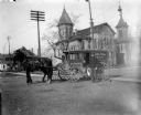
| Date: | 1908 |
|---|---|
| Description: | Joseph Pearson, milkman, poses with his wagon and team of horses in front of the Madison High School at the corner of Wisconsin Avenue and Johnson Street. |

| Date: | 1896 |
|---|---|
| Description: | A hand-colored Map of Jefferson County, Wisconsin, shows township and section divisions, towns, villages and post offices, rural residents, railroads, road... |

| Date: | 1909 |
|---|---|
| Description: | A map of Langlade County, Wisconsin that shows townships and ranges, towns, cities and villages, wagon roads, churches, schools, sawmills, town halls, chee... |

| Date: | 1915 |
|---|---|
| Description: | This 1915 map of Lincoln County, Wisconsin, shows the township and range grid, towns, cities and villages, lakes and streams, residences, churches, school ... |

| Date: | 1926 |
|---|---|
| Description: | A map of Lincoln County, Wisconsin that shows the township and range grid, towns, cities and villages, lakes and streams, residences, churches, school hous... |

| Date: | |
|---|---|
| Description: | This 1907 map of Outagamie County, Wisconsin, shows the township and range grid, towns, sections, cities and villages, railroads, wagon roads, churches, sc... |

| Date: | 1922 |
|---|---|
| Description: | This map of Outagamie County, Wisconsin, from the first half of the 20th century, shows the township and range grid, towns, sections, cities and villages, ... |

| Date: | |
|---|---|
| Description: | This map from the early 20th century shows the township and range grid, towns, sections, cities and villages, railroads, roads, schools, churches, cemeteri... |

| Date: | 1914 |
|---|---|
| Description: | This 1914 map of Price County, Wisconsin, shows land for sale by the Good Land Company and Dewitt van Ostrand of Phillips. Also shown are the township and ... |

| Date: | 1925 |
|---|---|
| Description: | This map of Price County, Wisconsin, from the early 20th century shows the township and range system, towns, sections, cities and villages, railroads, high... |

| Date: | 1871 |
|---|---|
| Description: | This map of Barron County, Wisconsin, shows the township and range grid, towns, sections, cities and villages, post offices, dwellings, schools, roads, swa... |

| Date: | 1896 |
|---|---|
| Description: | This late 19th century map of Walworth County, Wisconsin, shows the township and range grid, towns, sections, villages and post offices, roads, railroads, ... |

| Date: | 1870 |
|---|---|
| Description: | This 1870 map of Brown County, Wisconsin, shows the township and range grid, towns, sections, cities, villages and post offices, land ownership, roads, rai... |

| Date: | 1914 |
|---|---|
| Description: | This early-20th century map of Clark County, Wisconsin, shows the township and range grid, sections, cities and villages, wagon roads, railroads, settlers,... |

| Date: | 1905 |
|---|---|
| Description: | This early 20th century map of Door County, Wisconsin, shows the township and range grid, towns, sections, cities and villages, landownership and acreages,... |

| Date: | 1944 |
|---|---|
| Description: | Shows roads, railroads, schools, dairy plants, seaplane bases, wayside parks, and commercial/municipal fields. "Marathon Forms Map Service, Wisconsin repre... |
If you didn't find the material you searched for, our Library Reference Staff can help.
Call our reference desk at 608-264-6535 or email us at:

