 Filter: Categories of Wisconsin Historical Images
Filter: Subject of Food industry and trade
Filter: Subject of city halls
Filter: Categories of Wisconsin Historical Images
Filter: Subject of Food industry and trade
Filter: Subject of city halls

| Date: | 1880 |
|---|---|
| Description: | Bird's-eye map over the Mississippi River of Fountain City. Paddle steamers and steamboats are on the river, and bluffs are in the background. |
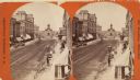
| Date: | 1870 |
|---|---|
| Description: | Stereograph; view of the earlier City Hall building, on Market Square at the corner of E. Water Street and Oneida Street. Several signs are in the image, i... |
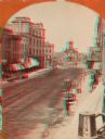
| Date: | 1870 |
|---|---|
| Description: | Stereograph; view of the earlier City Hall building, on Market Square at the corner of E. Water Street and Oneida Street. Several signs are in the image, i... |

| Date: | 1909 |
|---|---|
| Description: | A map of Langlade County, Wisconsin that shows townships and ranges, towns, cities and villages, wagon roads, churches, schools, sawmills, town halls, chee... |

| Date: | 1926 |
|---|---|
| Description: | A map of Lincoln County, Wisconsin that shows the township and range grid, towns, cities and villages, lakes and streams, residences, churches, school hous... |

| Date: | |
|---|---|
| Description: | This 1907 map of Outagamie County, Wisconsin, shows the township and range grid, towns, sections, cities and villages, railroads, wagon roads, churches, sc... |

| Date: | 1922 |
|---|---|
| Description: | This map of Outagamie County, Wisconsin, from the first half of the 20th century, shows the township and range grid, towns, sections, cities and villages, ... |

| Date: | |
|---|---|
| Description: | This map from the early 20th century shows the township and range grid, towns, sections, cities and villages, railroads, roads, schools, churches, cemeteri... |

| Date: | 1914 |
|---|---|
| Description: | This 1914 map of Price County, Wisconsin, shows land for sale by the Good Land Company and Dewitt van Ostrand of Phillips. Also shown are the township and ... |

| Date: | 1914 |
|---|---|
| Description: | Map shows school houses, creameries, post offices, saw mills, grist mills, churches, cemeteries, town halls, stores, roads, state roads, and railroads. "Co... |
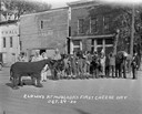
| Date: | 10 24 1930 |
|---|---|
| Description: | A line of clowns and assorted pantomime animals dressed up for Cheese Day. The animals include; a horse, a woodchuck, a bear, a giraffe and an elephant. A ... |
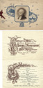
| Date: | 04 30 1889 |
|---|---|
| Description: | Front cover and first two pages of the souvenir menu for the centennial of George Washington's inauguration at the Hotel Marlborough. The cover features a ... |

| Date: | 03 24 1950 |
|---|---|
| Description: | Front cover of a farewell dinner menu from the Italian Line ship Saturnia, with three Commedia dell' Arte characters: Stenterello, who wears a jacke... |
If you didn't find the material you searched for, our Library Reference Staff can help.
Call our reference desk at 608-264-6535 or email us at: