 Filter: Categories of Wisconsin Historical Images
Filter: Subject of Folklore
Filter: Subject of water
Filter: Categories of Wisconsin Historical Images
Filter: Subject of Folklore
Filter: Subject of water
| Date: | |
|---|---|
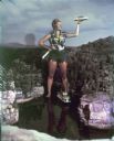
| Description: | Woman dressed as Paulina Bunyan (female version of Paul Bunyan) standing in the Minirama recreation of the Wisconsin Dells. She holds an axe in one hand an... |
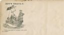
| Date: | 1860 |
|---|---|
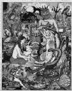
| Description: | Jefferson Davis and six sailors sail in a tea cup. A pirate flag flies overhead. One sailor is in the "crow's nest." Another is using a paddle. Three sailo... |
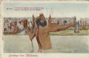
| Date: | 1914 |
|---|---|
| Description: | Postcard of the Milwaukee lakefront. In the foreground is an image of Neptune standing in Lake Michigan holding a trident in one hand and a beer stein in t... |

| Date: | 1941 |
|---|---|
| Description: | This map is ink and watercolor on cardboard and shows Native American legends and villages pictorially. Trails are also shown. |

| Date: | 1930 |
|---|---|
| Description: | Original map made with watercolor and inkwash. Includes a legend of buildings, roads, natural features and other details of the lodge. Inset at bottom has ... |

| Date: | 01 1969 |
|---|---|
| Description: | A map of Oneida county, which includes a small drawing of a hodag. |
| Date: | 1987 |
|---|---|
| Description: | Imaginative pen-and-ink drawing titled, "Fish Tales (The Truth is Irrelevant, A Lie Well Told Lives Forever)." Sid adds the following words to describe the... |
| Date: | 1985 |
|---|---|
| Description: | Imaginative pen-and-ink drawing that appeared in the Capitol Times May 3, 1985 with Sid's caption: "Charlie Lunker Bass is down at the rustic barber... |
| Date: | 1986 |
|---|---|
| Description: | Imaginative pen-and-ink drawing that appeared in the Capital Times on May 3, 1986 with Sid's caption: "Before fish, all men are created equal. Fish,... |
| Date: | 1974 |
|---|---|
| Description: | Imaginative pen-and-ink drawing of a fisherman in waders, standing in ankle deep water and bending over with one hand in the water. He is looking towards h... |

| Date: | 1627 |
|---|---|
| Description: | Map of North and South America showing settlements, rivers, lakes, mountains, islands and regions of the western hemisphere. It includes an inset map of Gr... |

| Date: | 1690 |
|---|---|
| Description: | A mysterious mixture of mythology, ancient geography, and late 17th century knowledge of the American coastline. This map shows North and South America, bu... |

| Date: | 1700 |
|---|---|
| Description: | Map of the western hemisphere showing settelments, coastal features, islands, rivers, lakes, and pictoral representations of forests and mountains. The Gre... |

| Date: | 1790 |
|---|---|
| Description: | Map of North America showing cities, states, Native American land, regions, lakes, and rivers. A few notes appear throughout the map, particularly west of ... |

| Date: | 1777 |
|---|---|
| Description: | This important map highlights the frantic desire and search for the north west passage. It shows a few settlements and mountains in Russia, north west Amer... |

| Date: | 1722 |
|---|---|
| Description: | Map of North America including mountains, rivers, lakes, regions, and a few of the most important cities. A highly unusual map with interesting inaccuracie... |

| Date: | 1740 |
|---|---|
| Description: | Map including the regions and cities of the northern half of North America. Native American land, rivers, lakes, mountains are labeled. Mountains, marshes,... |

| Date: | 1772 |
|---|---|
| Description: | Map of the north west portion of America and Canada, as well as a small section of eastern Russia. Lakes, rivers, Native American land and the occasional ... |

| Date: | 1778 |
|---|---|
| Description: | Map of European claims in North America, with France shown as having claim to the most land, and the British colonies confined to east of the Appalacian Mo... |

| Date: | 1770 |
|---|---|
| Description: | Map of North America showing the boundaries between French, Spanish, and English claims after the French and Indian War. Kitchin includes numerous place na... |
If you didn't find the material you searched for, our Library Reference Staff can help.
Call our reference desk at 608-264-6535 or email us at: