Map or Atlas
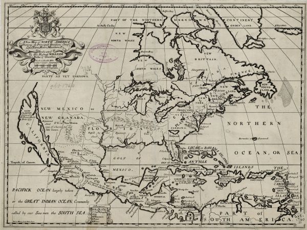
A New Map of North America Shewing its Principal Divisions, Chief Cities, Townes, Rivers, Mountains &c

| Map of North America including mountains, rivers, lakes, regions, and a few of the most important cities. A highly unusual map with interesting inaccuracies, even for its time. The Appalachian Mountains run from Lake Erie west past the Mississippi River. The Mississippi River itself is shown as draining out of present day Texas rather than Louisiana. The shape of Florida is very odd. A few notes appear on the map, with dates and explanations of various discoveries. On top of the title cartouche a unicorn and lion hold up a coat of arms. The map is dedicated to William, Duke of Glocester. |
| Image ID: | 123911 |
|---|---|
| Creation Date: | 1722 |
| Creator Name: | Burghers, Michael |
| City: | |
| County: | |
| State: | |
| Collection Name: | Map Collection |
| Genre: | Map or Atlas |
| Original Format Type: | prints, fine-art |
| Original Format Number: | H GX81 1760 B |
| Original Dimensions: | 37 x 49 cm |
| Map engraved by Michael Burghers. Part of a school atlas made by Edward Wells on the occasion of William Duke of Glocheser's schooling at Oxford. |
| Lion |
| Engraving |
| Cities and towns |
| Folklore |
| Maps |
| Islands |
| Mountains |
| Lakes |
| Mississippi River |
| Rivers |
| This image is issued by the Wisconsin Historical Society. Use of the image requires written permission from the staff of the Collections Division. It may not be sold or redistributed, copied or distributed as a photograph, electronic file, or any other media. The image should not be significantly altered through conventional or electronic means. Images altered beyond standard cropping and resizing require further negotiation with a staff member. The user is responsible for all issues of copyright. Please Credit: Wisconsin Historical Society. |
| Location: | Wisconsin Historical Society Archives, 4th Floor, Madison, Wisconsin |
|---|
