 Filter: Categories of Wisconsin Historical Images
Filter: Subject of Folklore
Filter: Subject of transportation
Filter: Categories of Wisconsin Historical Images
Filter: Subject of Folklore
Filter: Subject of transportation

| Date: | |
|---|---|
| Description: | Woman dressed as Paulina Bunyan (female version of Paul Bunyan) standing in the Minirama recreation of the Wisconsin Dells. She holds an axe in one hand an... |
| Date: | |
|---|---|
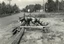
| Description: | Hodag standing on a board balanced on logs near a road. There is a gasoline filling station in the background. |
| Date: | 11 25 1976 |
|---|---|
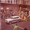
| Description: | Thanksgiving Day Parade, either Macy's Parade in Manhattan, New York, or Gimbels' Parade in Philadelphia, Pennsylvania. A tan and brown International Harve... |
| Date: | 11 25 1976 |
|---|---|
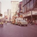
| Description: | Macy's Thanksgiving Day Parade. The Macy's storefront can be seen in the background. A red and white International Harvester Scout 4x4 truck is towing a fl... |

| Date: | 1941 |
|---|---|
| Description: | This map is ink and watercolor on cardboard and shows Native American legends and villages pictorially. Trails are also shown. |

| Date: | 1930 |
|---|---|
| Description: | Original map made with watercolor and inkwash. Includes a legend of buildings, roads, natural features and other details of the lodge. Inset at bottom has ... |

| Date: | 01 1969 |
|---|---|
| Description: | A map of Oneida county, which includes a small drawing of a hodag. |
| Date: | 1987 |
|---|---|
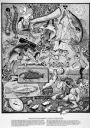
| Description: | Imaginative pen-and-ink drawing titled, "Fish Tales (The Truth is Irrelevant, A Lie Well Told Lives Forever)." Sid adds the following words to describe the... |
| Date: | 1986 |
|---|---|
| Description: | Imaginative pen-and-ink drawing that appeared in the Capital Times on May 3, 1986 with Sid's caption: "Before fish, all men are created equal. Fish,... |

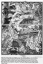
| Date: | 1627 |
|---|---|
| Description: | Map of North and South America showing settlements, rivers, lakes, mountains, islands and regions of the western hemisphere. It includes an inset map of Gr... |

| Date: | 1700 |
|---|---|
| Description: | Map of the western hemisphere showing settelments, coastal features, islands, rivers, lakes, and pictoral representations of forests and mountains. The Gre... |

| Date: | 1759 |
|---|---|
| Description: | Map of north eastern Canada and parts of New England, showing settlements, cities, portages, Native American land, mountains, lakes, and rivers. The unusua... |

| Date: | 1967 |
|---|---|
| Description: | This colored map published by the State Historical Society of Wisconsin shows key points of interest telling the story of Wisconsin's earliest settlement a... |
If you didn't find the material you searched for, our Library Reference Staff can help.
Call our reference desk at 608-264-6535 or email us at: