 Filter: Categories of Wisconsin Historical Images
Filter: Subject of Foliage
Filter: Subject of maps
Filter: Categories of Wisconsin Historical Images
Filter: Subject of Foliage
Filter: Subject of maps
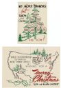
| Date: | 1950 |
|---|---|
| Description: | Holiday card with the "family tree" of D.C. III (David Clark Everest) and Rita Everest, on the front, and a map of the U.S.A. on the inside showing the two... |

| Date: | 1918 |
|---|---|
| Description: | Holiday card with the American Eagle, gripping lightening bolts, ribbons and holly in his talons. In the background are clouds and a map of the United Stat... |

| Date: | 1958 |
|---|---|
| Description: | Meeting of the 26th of July Movement in the woods of Oriente Province during the Cuban Revolution. Fidel Castro, Juan Almeida Bosque and Vilma Espin crouch... |

| Date: | 1958 |
|---|---|
| Description: | Meeting of the 26th of July Movement in the woods of Oriente Province during the Cuban Revolution. A number of participants, including Vilma Espin and Juan... |

| Date: | 1958 |
|---|---|
| Description: | Meeting of the 26th of July Movement in Oriente Province during the Cuban Revolution. A number of participants, including Vilma Espin, Raúl Castro and Juan... |

| Date: | 1958 |
|---|---|
| Description: | Meeting of the 26th of July Movement in Oriente Province during the Cuban Revolution. Vilma Espin stands in the middle with a gun, and Raúl Castro and Juan... |

| Date: | 1746 |
|---|---|
| Description: | A map of the western hemisphere, including parts of western Europe and Africa, showing the division of the Americas by the European powers. Weapons and fol... |

| Date: | 1747 |
|---|---|
| Description: | Map of America showing rivers, lakes, mountains, and regions, but primarily focusing on the French and Native American settlements along the Mississippi th... |

| Date: | 1776 |
|---|---|
| Description: | Map of North America east of Mexico showing important cities, the colonies, regions, Native American land, mountains, lakes, and rivers. A series of lakes,... |

| Date: | 1700 |
|---|---|
| Description: | Map of the British colonies in North America at the beginning of the eighteenth century. It includes five inset maps of Nova Scotia, Jamaica, Bermuda, Barb... |
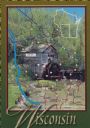
| Date: | 1988 |
|---|---|
| Description: | Text on front, at the foot: "Wisconsin." The color image of Hyde's Mill has an overlay of a map of the southwest corner of Wisconsin inside a red frame. Th... |
If you didn't find the material you searched for, our Library Reference Staff can help.
Call our reference desk at 608-264-6535 or email us at: