 Filter: Categories of Wisconsin Historical Images
Filter: Subject of Flour mills
Filter: Year of 1800-1899
Filter: Subject of transportation
Filter: Categories of Wisconsin Historical Images
Filter: Subject of Flour mills
Filter: Year of 1800-1899
Filter: Subject of transportation
| Date: | 1885 |
|---|---|
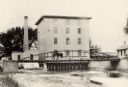
| Description: | View of the Rockdale mill, a grist and sawmill built in 1847 by Thomas and Nathan Van Horn. A group of people are standing on a sidewalk or loading dock on... |

| Date: | 1853 |
|---|---|
| Description: | Farwell's Mill on the Yahara River at Lake Mendota. |

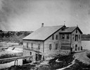
| Date: | 1879 |
|---|---|
| Description: | The Reliance Flooring Mill. Men are posing in front, and another man is on a horse-drawn vehicle near the loading dock. The mill building was physically mo... |
| Date: | 1885 |
|---|---|
| Description: | Lemonweir River flour mill built in 1852 and torn down in 1943. Mill and site were purchased in 1926 by the Wisconsin Power and Light Company for a power p... |
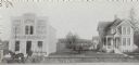
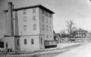
| Date: | 1899 |
|---|---|
| Description: | The Smith M. Jacobs Flour and Feed Store (left) and residence (right), 301 and 303 Monroe Street. The address renumbered within the next five years to 1701... |
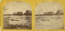
| Date: | 1870 |
|---|---|
| Description: | Stereograph view of the flour mill district. The Cedar Street Bridge is in the background, and the mills are, right to left going back, the Winnebago Flour... |

| Date: | 1870 |
|---|---|
| Description: | Stereograph of flour mill district. The Walnut Street bridge is in the background and the mill to the right is the Atlantic Mills (Neenah Stone Mills in 18... |
| Date: | 1890 |
|---|---|
| Description: | View towards the mill on the Yahara River at the outlet of Lake Mendota. The mill was built in 1850 by Governor Farwell. A man is standing on the bridge wi... |
| Date: | 1858 |
|---|---|
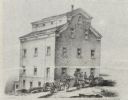
| Description: | Drawing of the exterior of the Shopiere Flouring Mill. Several men, some in a horse-drawn wagon are in front of the building. |

| Date: | 1871 |
|---|---|
| Description: | This map of Barron County, Wisconsin, shows the township and range grid, towns, sections, cities and villages, post offices, dwellings, schools, roads, swa... |

| Date: | 1858 |
|---|---|
| Description: | Map showing roads, mills, and rivers. Date conjectured from presence of Ensign’s Mill and Pitt’s Mill and location of Nekoosa. |

| Date: | 1885 |
|---|---|
| Description: | A detail of a Sanborn map including Catfish Creek and Westport Road by Lake Mendota. |

| Date: | 1855 |
|---|---|
| Description: | This map is ink, pen, and watercolor on paper and shows plat of the town, local streets, lots by number, U.S. subdivisions in red lines, Mineral Point Rail... |
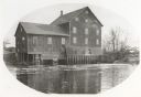
| Date: | 1884 |
|---|---|
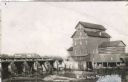
| Description: | View across river of the Model Roller Mills, with the date 1884, with a railroad trestle is on the left. The mill wheel is turning. |

| Date: | 1851 |
|---|---|
| Description: | This map shows townships, villages, Indian villages, railroads, roads, mills, prairies, swamps, and canals. An inset map shows a plat of the copper distric... |
| Date: | 1898 |
|---|---|
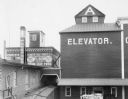
| Description: | Slightly elevated view of the Cereal Mills Company. Men are working near a horse-drawn wagon near an entrance to a grain elevator in the lower right. Railr... |
| Date: | 1850 |
|---|---|
| Description: | A grist mill on the Yahara River at the outlet of Lake Mendota. The mill, called Farwell's Madison Mills was built in 1850 by Governor Farwell. The origina... |

| Date: | 1890 |
|---|---|
| Description: | Dow Flour Mill letterhead, with an engraving of the mill building, with a locomotive, a ship on the lake, and the dome of the Wisconsin State Capitol. |

| Date: | 1877 |
|---|---|
| Description: | A page from an illustrated historical atlas showing four residences, a hotel and the flouring mill of John Ochsner. |
If you didn't find the material you searched for, our Library Reference Staff can help.
Call our reference desk at 608-264-6535 or email us at:
